2. 水利部水土保持监测中心, 100053, 北京
-
项目名称
- 国家自然科学基金"极端降水对干热河谷坡面和流域尺度水沙关系的影响及其驱动机制"(42007068)
-
第一作者简介
- 郭乾坤(1987-), 男, 博士, 高级工程师。主要研究方向: 水沙变化分析评价, 土壤侵蚀模型应用。E-mail: guoqiankun@iwhr.com
-
通信作者简介
- 单志杰(1980-), 男, 博士, 正高级工程师。主要研究方向: 水土流失风险与水土保持生态效益评价。E-mail: shanzhj@iwhr.com
-
文章历史
-
收稿日期:2022-10-20
修回日期:2023-10-27
2. 水利部水土保持监测中心, 100053, 北京
2. The Center of Soil and Water Conservation Monitoring, Ministry of Water Resources, 100053, Beijing, China
我国水土流失一般由几次大雨或暴雨造成[1-4]。较大场次降雨事件对径流泥沙动态过程的影响及其机制研究成为近年来的研究热点之一[5]。近年来相关研究主要集中在黄土高原地区[6-7],如延河[8]、大理河[9]和无定河[10]等流域。这些研究明确黄土高原次降雨事件降雨特征的变化及其对水沙变化的影响,为科学评价水土保持措施效益、科学认识极端降雨情境下产洪产沙规律、科学配置水土流失防治措施等提供重要依据;然而,与黄土高原较为丰富的研究相比,我国其他地区,特别是西南横断山区次降雨事件对水沙变化的研究还相对缺乏。
我国西南横断山区山高谷深,形成大量空间散布的狭长干热河谷,具有高温低湿、植被稀疏、生态环境较为脆弱等特征,加之人为活动频繁,易造成较为严重的水土流失。近年来,不少学者选择干热河谷所在的典型流域开展水沙特征变化与归因分析,定量评价降雨和人为活动对水沙变化的影响,其中以龙川江流域的研究[11-15]最为丰富。然而,这些研究多在年尺度开展,且多以年降雨量表征降雨指标,不能充分反映次降雨事件中降雨强度、降雨历时等关键降雨指标对产流产沙的影响,且研究采用的降雨点较少,不能准确反映横断山区复杂地形条件下的降雨空间分异特征。近年来,干热河谷次降雨事件的研究多集中于坡面尺度,以径流小区定位观测试验为主[16-19],缺少流域尺度上降雨特征对水沙变化的影响研究。总之,干热河谷地区次降雨事件对流域尺度水沙特征的影响还少见报告,一定程度上影响对次降雨事件水土流失规律的准确认识,也影响水土保持措施的精准配置。
基于上述情况,笔者选取位于横断山区的金沙江一级支流龙川江作为研究区。该流域下游的元谋盆地为典型干热河谷地区,流域在整个横断山区具有代表性。笔者基于流域内各降雨站点长序列实测资料和流域出口小黄瓜园水文站水文泥沙测验资料,分析不同时期次降水条件下水沙变化特征,评价水土保持措施对水沙变化的影响,以期为后续水土流失治理提供科学参考。
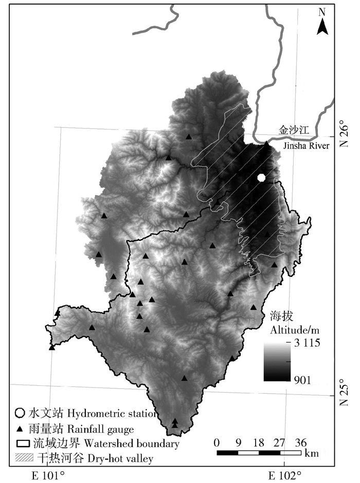
1 研究区概况龙川江为长江上游金沙江南岸的一级支流,位于云南省楚雄彝族自治州境内,流域面积9 255 km2(图 1)。龙川江干流小黄瓜园水文站控制的集水区面积5 560 km2。流域上中游是山地丘陵区,属亚热带季风气候,下游元谋盆地为干热河谷,属干热气候。流域多年平均年降水量约900 mm,其中干热河谷区约600 mm。干热河谷区由于高温低湿,植被缺少,历来水土流失较为严重[20-22]。自1990年以来,包括龙川江流域在内的金沙江流域先后启动长江防护林工程、“长治”工程、天然林资源保护保护工程、退耕还林工程和生态恢复工程等项目[23],同时开展坡改梯、水库建设和水窖等小型水利设施建设项目[24],流域下垫面发生明显变化,生态环境得到明显改善。

|
图 1 龙川江流域的位置及雨量站、水文站分布 Fig. 1 Location of the Longchuanjiang watershed and the distribution of hydrometric stations and rainfall gauges |
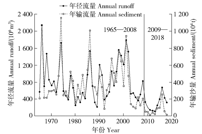
基于中华人民共和国水文年鉴资料,摘录得到1966—2018年龙川江流域30个雨量站逐日降雨量、小黄瓜园水文站逐日径流量和输沙量等数据,并据此计算得到小黄瓜园站1966—2018年均径流量和输沙量(图 2)。可见,1966—2018年年均径流量和输沙量均呈下降趋势,运用Mann-Kendall趋势分析方法研究发现径流输沙均在2008年发生趋势性突变,因此将径流输沙序列划分为1966—2008和2009—2018年2个时段,即基准期和变化期。

|
图 2 龙川江流域小黄瓜园水文站逐年径流泥沙变化 Fig. 2 Variations of annual runoffs and sediments in the Xiaohuaguayuan hydrometric station |
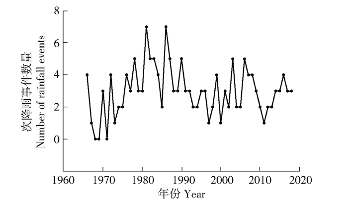
基于已获取的降雨和径流泥资料,筛选典型次降雨事件,并根据同一降雨事件中各雨量站实测降雨数据,通过反距离加权空间插值得到该次事件平均降雨量。为有效筛选能引起产流产沙的降雨事件,笔者规定:当流域内至少1个雨量站的日降雨量>25 mm时,即流域内产生气象学意义上的大雨及以上级别降雨时,方计算次降水事件平均降雨量。同时考虑到同一次降水事件受降雨时段、站点位置、径流流速和输沙距离等因素的影响,水文站观测的径流输沙过程往往滞后于降雨过程,因此在筛选次降水事件时,适当参考水文年鉴中降水要素摘录表中各雨量站降雨强度较大时段的洪水过程资料,对降雨和径流输沙过程进行时间上的对应和匹配。筛选后共得到次降水事件158场,其中基准期128场,变化期30场(图 3)。

|
图 3 小黄瓜园水文站筛选得到的逐年次降雨事件数量 Fig. 3 Number of rainfall events in each year in the Xiaohuangguayuan hydrometric station |
基于158场次降雨事件平均降雨量,划分不同降雨量等级,分别为一级(<20 mm)、二级(≥20~30 mm)、三级(≥30~40 mm)、四级(≥40~50 mm)、五级(≥50~70 mm)、六级(≥70~100 mm)和七级(≥100 mm),统计分析2期各降雨量等级的平均降雨量、径流量和输沙量,对比分析2期同一降雨量等级下径流量和输沙量的差异。2期各降雨量等级基本统计信息见表 1。
| 表 1 各降雨量等级和暴雨覆盖面积比例等级2期降雨事件数量 Tab. 1 Number of rainfall events for rainfall grades and area proportion grades for torrential rainfall in both periods |
针对每一场次降水事件,统计流域内不同降雨量等级的覆盖面积。根据国家标准GB/T 28592—2012《降水量等级》,日降雨量在50~99.9 mm即为暴雨等级,因此选择四级以上降雨覆盖面积比例这一指标以表征每场次降雨中暴雨覆盖面积比例情况。根据次降雨事件暴雨覆盖面积比例的差异,划分6个不同等级(表 1)。统计分析2期暴雨覆盖面积比例各等级的平均降雨量、径流量和输沙量等,以对比分析流域发生较大场次降雨时2期同一覆盖面积比例等级下径流量和输沙量的差异。
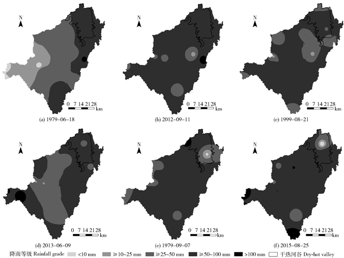
2.3 降雨特征相似的2期次降雨事件对比分析选择基准期和变化期降雨特征相似的典型次降雨事件,对比分析2期相似次降雨事件径流和输沙的差异,以消除降雨因素对径流输沙变化的影响。一般而言,降雨特征相似包括降雨量相近、降雨空间分布类似、降雨强度和历时相近等。考虑到历史次降水事件多缺少详细过程资料,因此笔者主要以平均降雨量和降雨空间分布相似作为选择条件。经筛选,共选择3组6次典型次降雨事件,分别发生于1979年6月18日和2012年9月11日、1999年8月21日和2013年6月9日、以及1979年9月7日和2015年8月25日,分别计算全流域和干热河谷范围内25、50和100 mm等雨量线空间分布情况和覆盖面积,并统计各次降雨事件的平均降雨量、径流量和输沙量。
3 结果与分析 3.1 2期相同降雨量等级次降雨事件对比对比分析2期各降雨量等级的平均降雨量、径流量和输沙量(图 4),发现相同降雨量等级2期的降雨量均值十分接近,变化期降雨量均值为基准期的93.49%~101.42%,平均为100.29%。可见,2期同一降雨量等级的降雨量没有明显区别,但2期径流与输沙均呈现出明显的差异:变化期径流量均为基准期30.42%~70.02%,平均为48.72%,变化期输沙量均值为基准期的18.61%~57.71%,平均为29.06%。对所有降雨量等级加权平均,基准期和变化期次降雨量分别为43.75和43.88 mm,径流量分别为3 793万和1 848万m3,输沙量分别为45.77万和13.30万t。可见,同一降雨量等级下,与基准期相比,变化期的径流量和输沙量均出现明显下降。这可能是由于水土保持生态建设主导下的下垫面变化造成的。

|
图 4 2期相同降雨量等级和暴雨覆盖面积比例等级次降雨事件对比 Fig. 4 Comparison of rainfall events in both periods for different rainfall grades (left) and area proportion grades for torrential rainfall (right) |
对2期次降雨事件暴雨覆盖面积比例进行分级,并对相同等级的平均降雨量、径流量和输沙量等进行对比(图 4),可见,变化期降雨量均为基准期的94.96%~117.01%,平均为99.05%;径流量均值为基准期的9.07%~59.09%,平均为48.77%;输沙量均值为基准期的5.05%~49.21%,平均为28.97%。对所有暴雨覆盖面积比例分级加权平均,发现基准期和变化期平均降雨量分别为43.13和42.72 mm,而径流量分别为3 736万和1 822万m3,输沙量分别45.29万和13.12万t。这说明变化期的径流量和输沙量,与基准期相比,均呈现出较为明显的下降。
3.3 2期典型降雨特征相似次降雨事件径流输沙对比筛选出的3组6次典型次降雨事件基本信息见表 2,可见,每组中的2次典型次降雨事件的降雨量、不同等级降雨空间分布和覆盖面积均较为接近(图 5),但次降雨事件的径流量和输沙量均呈现出明显的差异。具体而言,每组内变化期次降雨事件的输沙量均明显低于同组内基准期,3组内变化期次降雨事件的输沙量分别为基准期的62.30%、5.55%和31.50%,平均值为33.12%;变化期次降雨事件的径流量分别为基准期的168.12%、3.56%和50.80%,平均值为74.16%。可见,变化期仅有2012年9月11日的次降雨事件径流量高于基准期,这可能是因为该次降雨事件小黄瓜园水文站集水区范围内50 mm以上降雨等级覆盖面积(5 137.5 km2)远大于1979年6月18日的次降雨事件(2 083.8 km2)。但总体而言,对于降雨特征相似的次降雨事件,变化期次降雨事件的径流量和输沙量整体上明显低于基准期。
| 表 2 筛选的次降雨事件基本信息 Tab. 2 Basic information for selected rainfall events |

|
图 5 2期降雨条件相似的典型次降雨事件空间分布对比 Fig. 5 Comparisons of spatial distribution of typical similar rainfall events between the two periods |
基于小黄瓜园水文站长序列实测降雨—径流—泥沙资料,笔者对基准期和变化期相同降雨量等级、暴雨覆盖面积比例相同等级和降雨特征相似等3种类型次降雨事件径流量和输沙量进行对比,发现在降雨特征未发生明显变化的情况下,变化期径流量和输沙量相较于基准期明显下降,说明下垫面变化可能是影响水沙变化的主要原因。自20世纪90年代以来,龙川江流域实施一系列水土保持生态工程和林业工程,如7期“长治工程”、国债小流域综合治理工程和长江上游水土保持世行贷款项目,包括封禁治理、水保林种植、种草、经果林种植、坡改梯工程和库塘坝池等水土保持措施,取得良好效果。元谋县森林覆盖率由1985年的5.2%上升至2007年的46.6%[23-24]。上述项目的实施显著改善龙川江流域,特别是干热河谷地区的下垫面条件,起到减流减沙的良好效果。
龙川江流域的水土流失主要由几场暴雨引起,已有研究表明,全球变化背景下龙川江流域等干热河谷地区极端降水事件趋多趋强[25],可能会对流域水沙情势造成影响,而横断山区复杂的地形条件又进一步增强极端降水事件的复杂性和不确定性。由于历史降雨资料的局限性,笔者未针对降雨历时、降雨强度等降雨特征对水沙变化的影响进行深入分析,后续应基于高精度降雨数据,进一步加强对次降水事件降水特征对水沙变化的影响分析,以进一步科学认识降雨特征对水沙关系的影响,精准指导水土保持措施优化配置与管理。
5 结论1) 龙川江流域1966—2018年径流量和输沙量呈现明显下降趋势,其中2008年为突变年份。
2) 3种相似降雨条件下,变化期(2009—2018)径流量和输沙量均明显低于基准期(1966—2008),流域水土保持生态建设引起的下垫面变化是水沙减少的主要原因。
| [1] |
刘昌明, 洪宝鑫, 曾明煊, 等. 黄土高原暴雨径流预报关系初步实验研究[J]. 科学通报, 1965, 10(2): 68. LIU Changming, HONG Baoxin, ZENG Mingxuan, et al. Preliminary study on the rainstorm-runoff relationship prediction in the Loess Plateau[J]. Science Bulletin, 1965, 10(2): 68. |
| [2] |
LARSON W E, LINDSTORM M J, SCHUMACHER T E. The role of severe storms in soil erosion: A problem needing consideration[J]. Journal of Soil and Water Conservation, 1997, 52(2): 90. |
| [3] |
焦菊英, 王万中, 郝小品. 黄土高原不同类型暴雨的降水侵蚀特征[J]. 干旱区资源与环境, 1999, 13(1): 34. JIAO Juying, WAN Wanzhong, HAO Xiaopin. Precipitation and erosion characteristics of rainstorm in different pattern on Loess Plateau[J]. Journal of Arid Land Resources and Environment, 1999, 13(1): 34. |
| [4] |
卫伟, 陈利顶, 傅伯杰, 等. 黄土丘陵沟壑区极端降水事件及其对径流泥沙的影响[J]. 干旱区地理, 2007, 30(6): 896. WEI Wei, CHEN Liding, FU Bojie, et al. Extreme rainfall events and their effects on runoff and sediment yield in the loess hilly area[J]. Arid Land Geography, 2007, 30(6): 896. |
| [5] |
罗娅, 杨胜天, 刘晓燕, 等. 黄土高原次降雨径流产沙变化及其与雨强和植被盖度变化的相关性[J]. 干旱区研究, 2015, 32(4): 698. LUO Ya, YANG Shengtian, LIU Xiaoyan, et al. Changes in event-based rainfall-runoff- sediment and the relationships between these changes and rainfall intensity and vegetation coverage variations in Loess Plateau[J]. Arid Zone Research, 2015, 32(4): 698. |
| [6] |
刘晓燕. 黄河近年水沙锐减成因[M]. 北京: 科学出版社, 2016: 7. LIU Xiaoyan. Reasons for the dramatic decrease in runoff and sediment in recent years of the Yellow River[M]. Beijing: Science Press, 2016: 7. |
| [7] |
ZHAO Yang, CAO Wenhong, HU Chunhua, et al. Analysis of changes in characteristics of flood and sediment yield in typical basins of the Yellow River under extreme rainfall events[J]. Catena, 2019, 17: 31. |
| [8] |
陈瑞东, 温永福, 高鹏, 等. 极端降水条件下延河水沙特征对比分析及其影响因素[J]. 生态学报, 2018, 38(6): 1920. CHEN Ruidong, WEN Yongfu, GAO Peng, et al. Comparative analysis of flow and sediment characteristics of the Yanhe River under extreme rainfall conditions and research on influence factors[J]. Acta Ecologica Sinica, 2018, 38(6): 1920. |
| [9] |
韩丹丹, 穆兴民, 高鹏, 等. 极端降水条件下大理河流域水沙特征对比分析[J]. 中国水土保持科学, 2019, 17(6): 61. HAN Dandan, MU Xingmin, GAO Peng, et al. Comparative study on characteristics of runoff and sediment under extreme precipitation conditions in Dali River basin[J]. Science of Soil and Water Conservation, 2019, 17(6): 61. |
| [10] |
高海东, 李占斌, 李鹏, 等. 黄土高原暴雨产沙路径及防控: 基于无定河流域2017-07-26暴雨认识[J]. 中国水土保持科学, 2018, 16(4): 66. GAO Haidong, LI Zhanbin, LI Peng, et al. Paths and prevention of sediment during storm-runoff on the Loess Plateau: Based on the rainstorm of 2017-07-26 in Wuding River[J]. Science of Soil and Water Conservation, 2018, 16(4): 66. |
| [11] |
第宝锋, 崔鹏, 黄胜, 等. 近50年金沙江干热河谷区泥沙变化及影响因素分析: 以云南省元谋县为例[J]. 中国水土保持科学, 2006, 4(5): 20. DI Baofeng, CUI Peng, HUANG Sheng, et al. Sediment yields and impact factors in xerothermic valley in Jinsha River in the last 50 years: A case study in Yuanmou county, Yunnan province[J]. Science of Soil and Water Conservation, 2006, 4(5): 20. |
| [12] |
丁文荣. 金沙江下游元谋干旱河谷区水沙过程演变规律研究[J]. 水资源与水工程学报, 2017, 28(6): 20. DING Wenrong. Study on the evolution rule of water and sediment processes in Yuanmou arid valley of Jinsha River, Southwest China[J]. Journal of Water Resources & Water Engineering, 2017, 28(6): 20. |
| [13] |
张素. 龙川江流域气候与土地利用/覆被变化的径流泥沙响应[D]. 北京: 中国科学院大学, 2019: 47. ZHANG Su. Responses of runoff and sediment load to climate and land use changes in Longchuan watershed[D]. Beijing: University of Chinese Academy of Sciences, 2019: 47. |
| [14] |
周跃, 朱云梅, 吕喜玺. 人为活动对金沙江一级支流龙川江流域输沙量的影响分析[J]. 昆明理工大学学报(理工版), 2006, 31(1): 77. ZHOU Yue, ZHU Yunmei, LV Xixi. Human impacts on river sediment flux: A case study of Longchuan River basin[J]. Journal of Kunming University of Science and Technology (Science and Technology), 2006, 31(1): 77. |
| [15] |
ZHU Yunmei, LV Xixi, ZHOU Yue. Sediment flux sensitivity to climate change: A case study in the Longchuanjiang catchment of the upper Yangtze River, China[J]. Global and Planetary Change, 60(3/4): 429. |
| [16] |
陈奇伯, 王克勤, 刘芝芹, 等. 金沙江干热河谷封禁管护坡面的产流产沙特征[J]. 水土保持研究, 2006, 13(4): 217. CHEN Qibo, WANG Keqin, LIU Zhiqin, et al. Characteristic of runoff and sediment production on slope land of enclosure for recovering vegetation in dry-hot valley of Jinsha River Basin[J]. Research of Soil and Water Conservation, 2006, 13(4): 217. |
| [17] |
刘芝芹, 王克勤, 李艳梅. 金沙江干热河谷坡面降雨产流特征的分析[J]. 石河子大学学报: 自然科学版, 2010, 28(2): 227. LIU Zhiqin, WANG Keqin, LI Yanmei. Analysis of characteristics of precipitation and runoff production on slope land in dry-hot valley of Jinshajiang River[J]. Journal of Shihezi University (Natural Science), 2010, 28(2): 227. |
| [18] |
田波, 陈奇伯, 王克勤. 金沙江干热河谷不同处理坡面的产流产沙规律研究[J]. 西南林学院学报, 2006, 26(6): 44. TIAN Bo, CHEN Qibo, WANG Keqin. Study on runoff and sediment production on slopes treated by different measures in dry-hot valley of Jinshajiang River[J]. Journal of Southwest Forestry College, 2006, 26(6): 44. |
| [19] |
杨建霞, 雷孝章, 邱景, 等. 5°~25°坡耕地径流小区产流产沙规律[J]. 中国水土保持科学, 2008, 6(S1): 30. YANG Jianxia, LEI Xiaozhang, QIU Jing, et al. Law of water loss and soil erosion in the 5°- 25°sloping field[J]. Science of Soil and Water Conservation, 2008, 6(S1): 30. |
| [20] |
DONG Yifan, XIONG Donghong, SU Zheng'an, et al. The distribution of and factors influencing the vegetation in a gully in the dry-hot valley of southwest China[J]. Catena, 2014, 116: 60. DOI:10.1016/j.catena.2013.12.009 |
| [21] |
SU Zhengan, XIONG Donghong, DONG Yifan, et al. Simulated headward erosion of bank gullies in the dry-hot valley region of southwest China[J]. Geomorphology, 2014, 204: 532. DOI:10.1016/j.geomorph.2013.08.033 |
| [22] |
DUAN Xingwu, LIU Baoyuan, GU Zhijia, et al. Quantifying soil erosion effects on soil productivity in the dry-hot valley, southwestern China[J]. Environmental Earth Science, 2016, 75: 1164. DOI:10.1007/s12665-016-5986-6 |
| [23] |
楚雄彝族自治州林业局. 楚雄彝州林业50年[Z]. 云南楚雄: [出版者不详], 2008: 52. Bureau of Forestry of Chuxiong Yi Autonomous City. Fifty years of forestry in Chuxiong Yi Autonomous City[Z]. Chuxiong, Yunnan: [s. n. ], 2008: 52. |
| [24] |
楚雄彝族自治州水利局. 云南省楚雄彝族自治州水利志(1991—2005)[Z]. 云南楚雄: [出版者不详], 2008: 219. Bureau of Water Resources of Chuxiong Yi Autonomous City. Historical records of water resources in Chuxiong Yi Autonomous City (1991—2005)[Z]. Chuxiong, Yunnan: [s. n. ], 2008: 219. |
| [25] |
GUO Qiankun, CHENG Shiyue, QIN Wei, et al. Vertical variation and temporal trends of extreme precipitation indices in a complex topographical watershed in the Hengduan Mountain Region, China[J]. International Journal of Climatology, 2000, 40(6): 3250. |
 2024, Vol. 22
