2. 北京林业大学水土保持学院, 100083, 北京
-
项目名称
- "十二五"国家科技支撑课题"困难立地植被恢复技术研究与示范"(2015BAD07B02)
-
第一作者简介
- 杜胜莉(1993-), 女, 硕士研究生。主要研究方向:林业生态工程学。E-mail:13821662690@163.com
-
通信作者简介
- 朱清科(1956-), 男, 教授, 博士(后), 博士生导师。主要研究方向:林业生态工程学与水土保持学。E-mail:zhuqingke@sohu.com
-
文章历史
-
收稿日期:2017-09-19
修回日期:2017-11-08
2. 北京林业大学水土保持学院, 100083, 北京
2. College of Soil and Water Conservation, Beijing Forestry University, 100083, Beijing, China
陕北半干旱黄土区干旱少雨, 水土流失严重, 土壤水分是制约该区植被建设的限制因子, 对该区土壤水分的研究始终是黄土高原生态恢复的重点[1]。然而陡坡受微地形的影响, 其土壤水分存在异质性, 从而影响林草植被种群结构[2]; 因此, 研究黄土陡坡土壤水分对微地形的响应, 特别是不同降水年型条件下坡面微地形对土壤水分的影响机制, 可为黄土陡坡近自然水土保持林草植被构建提供科学依据[3]。
有关黄土高原林草地土壤水分的研究, 邵明安等[4]分析了土壤-水分-大气连统体对土壤水分的影响。张北赢等[5]分析了在不同降水年型[6]下沟壑区的土壤水分变化特征; 赵维军等[7]分析了土壤水分对降水特征的响应; 吴钦孝等[8]研究了土壤的物理性质与土壤水分的关系。王孟本等[9]研究了小叶杨的土壤水分生态; 王瑜等[10]对不同林分类型下土壤水分的垂直动态进行了研究; 王延平等[11]分析了植被在陡坡地的土壤水分时空变化; 王军等[12]分析了黄土高原流域土壤养分空间特征。并且前人从各研究尺度均开展了关于土壤水分的研究, 如路保昌等[13]对微地形土壤含水量进行了研究; 赵荟等[14]分析了合家沟流域干旱阳坡微地形土壤水分动态。
综上所述, 有关土壤水分研究已有大量成果, 然而针对35°以上的陡坡土壤水分研究较少。为此, 本文以陕北的吴起县合家沟流域为例, 将半阳极陡坡的缓台、塌陷、陡坎、切沟和浅沟5种微地形作为研究对象, 以微地形所在的原状坡面和缓坡作为对照, 分析极陡坡微地形土壤水分的变异特征及降水年型对陡坡微地形土壤水分的影响, 以期明确土壤水分对不同微地形的响应规律。
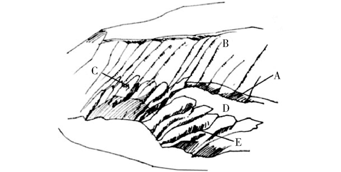
1 研究区概况研究区位于陕西省延安市吴起县合家沟流域(E 107°38′57″~108°32′49″, N 36°33′33″37°~24′27″), 流域内1957—2013多年平均降水量为478.3 mm。黄土高原土壤侵蚀严重, 水力、风力和重力侵蚀导致该区坡面形成形状各异的微地形, 分别有切沟、缓台、塌陷、浅沟、陡坎(图 1)。
|
A:陡坎Scarp; B:浅沟Ephemeral gully; C:塌陷Collapse; D:缓台Platform; E:切沟Gully. 图 1 黄土高原微地形素描示意图 Fig. 1 Schematic of micro-topography in the Loess Plateau |
在流域内以半阳坡缓坡(20°)和陡坡(30°)的原状坡作为对照, 分别选取半阳坡30°浅沟, 43°缓台、塌陷、陡坎、切沟作为观测样点(表 1), 采用时域反射计(TRIME-HD)手持式读表高精度TDR定点监测。每观测样点垂直埋设长度为2 m的PVC管, 每20 cm深度1层, 每层重复测定3次取平均值, 每次重复探针在水平方向上旋转120°[10]。
| 表 1 土壤水分监测点基本信息 Tab. 1 Details of monitoring points for soil moisture |
本研究选用目前国内比较常用的标准差SD、变异系数CV[2]对土壤水分的稳定性进行分析。
| $ \begin{array}{l} {C_{\rm{V}}} = \frac{{{\rm{SD}}}}{{\bar x}};\\ {\rm{SD}} = \sqrt {\frac{1}{{n-1}}\sum\limits_{i = 1}^n {\left( {{x_i}-\bar x} \right)} } 。\end{array} $ |
式中:x为样本土壤水分观测值平均值; xi为样本的第i个观测值, n为样本总个数。
2.3 降水年型划分根据目前国内广泛运用的划分标准, 将降水年型划分为丰水年和枯水年[15]。
丰水年:Pi>P+0.33W;
枯水年:Pi < P-0.33W。
式中:W为多年降水量的均方差, mm; Pi为逐年年降水量, mm; P为多年平均降水量, mm。
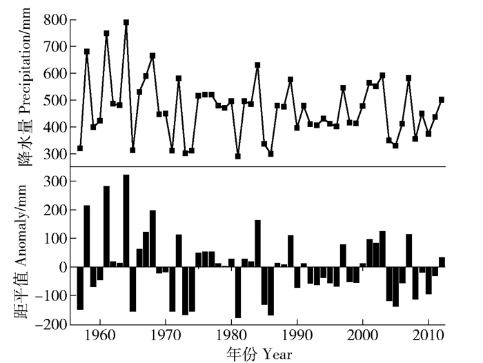
根据计算得出1957—2013多年平均降水量、降水量均方差分别为467.79、112.12 mm, 表现出多年平均降雨量和逐年距平值差异十分显著的特点(图 2)。为此, 本实验选取2011年-枯水年(436.60 mm)、2012年-丰水年(501.21 mm)作为对照年型, 对监测样点的土壤水分(0~180 cm)状况进行定位监测。
|
图 2 研究区1957—2012年年平均降雨量和逐年距平均变化图 Fig. 2 Average annual precipitation and anomaly for 1957-2012 in the survey area |
笔者采用EXCEL 2016软件对微地形土壤含水量进行处理, 采用Origin 8.0对不同降水年型与微地形土壤水分的关系进行绘制。
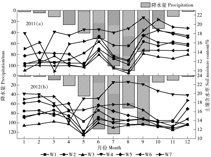
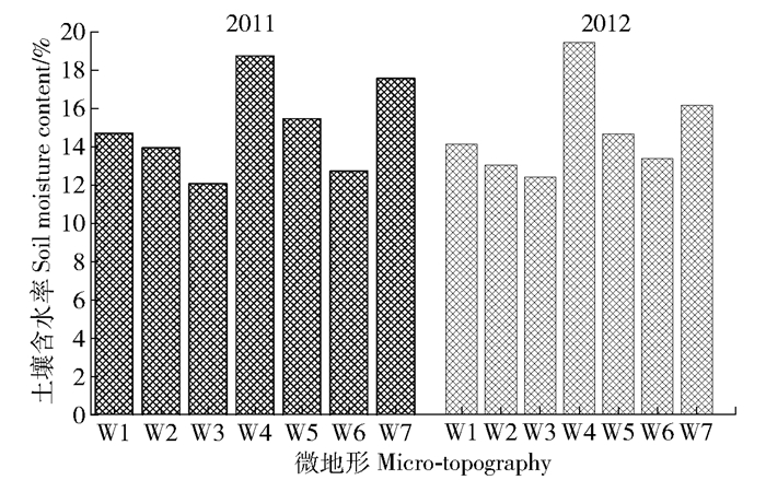
3 结果与分析 3.1 陡坡不同微地形土壤水分的季节动态由图 3可见, 2011年枯水年4—6月, 缓台(W1)、切沟(W4)和缓坡(W7)土壤含水量持续增长, 而塌陷(W2)、陡坎(W3)、浅沟(W5)和原状坡(W6)呈先减小再增长的趋势。这是由于气温回升, 雨量补给, 植被蒸腾和土壤蒸发作用加强[16]。6—12月土壤水分随降雨增大而滞后增大。这是因为枯水年雨季前降水量减小, 植被发育期间土壤水分未及时得到补充, 植被生长受到阻碍[17]。由图 3可见, 2012年-丰水年切沟土壤水分与降雨量增长趋势同步, 缓台、塌陷、陡坎、浅沟土壤水分的变化曲线呈W型。这是因为丰水年降水量增大, 导致土壤水分的入渗强度同步增大[10]。由图 4可见, 切沟的季节土壤水分含量均值最高, 陡坎的最低。前人[2, 18-20]的研究表明:黄土高原土壤水分活动可以被划分为4个阶段。本研究对该流域土壤活动划分为:弱失水阶段(2—5月); 缓慢恢复阶段(6—8月); 消耗阶段(9—11月); 相对稳定阶段(12—翌年2月)。
|
图 3 2011和2012年微地形土壤含水量月变化 Fig. 3 Average monthly precipitation and soil moisture content of micro-topography for 2011 and 2012 |
|
图 4 2011和2012年微地形土壤含水量年平均值 Fig. 4 Average soil moisture content of micro-topography for 2011 and 2012 |
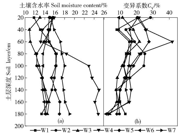
由图 5可见, 切沟在0~180 cm土层土壤含水量呈先减小后增大的趋势, 这是由于80~180 cm土层土壤的水分蓄积作用强[21]。同时, 切沟土壤含水量(0~180 cm土层)波动幅度大(13.16%~24.97%), 这是由于切沟本身的形状导致大量雨水聚集于沟底, 土壤入渗强度随滞留时间的延长而增大[7]。缓台、浅沟、缓坡的土壤水分在0~180 cm层次呈先增大后减小的趋势。图 5反映出微地形的土壤水分变异系数(Cv)在0~180 cm土层呈先增加后减小的趋势。
|
图 5 不同微地形土壤水分垂直分布特征 Fig. 5 Vertical distribution of soil moisture by different micro-topography |
相关研究采用变异系数[17-18]这一指标, 将土壤水分的垂直变化特征划分如下:速变层(Cv>30%)、活跃层(30%>Cv>20%)、次活跃层(20%>Cv>10%)和相对稳定层(10%>Cv>0%)。本研究对微地形的分层如下(表 2):速变层(fast change layer, FCL)、活跃层(active layer, AL)、次活跃层(stable layer, SL)和稳定层(most stable layer, MSL)。
| 表 2 土壤水分剖面垂直分层 Tab. 2 Vertical stratified results of soil water profile |
由表 2可见, 2011年-枯水年切沟土壤水分速变层最深, 而缓台、塌陷、陡坎、浅沟、原状坡和缓坡速变层深至60 cm, 活跃层深至100 cm, 稳定层深至100 cm以下。2012年-丰水年速变层消失, 除切沟、浅沟的活跃层较枯水年上移至60和80 cm以外, 其他观测点均为稳定层。
4 讨论微地形丰水年土壤水分季节排序为:切沟>缓坡>浅沟>原状坡>塌陷>缓台>陡坎(图 4)。邝高明等[22]的研究表明, 切沟的土壤含水量小于塌陷和缓台, 而本研究发现极陡坡切沟的土壤含水量最高, 是因为极陡坡坡度较大, 坡面难以滞留雨水, 致使雨水大量汇集在切沟沟底。陡坡陡坎年内土壤含水量最低, 受其自身形状与缓台影响较大, 雨水在缓台上滞留时间愈长, 导致在陡坎上滞留时间越短。不同坡度对于土壤含水量有显著影响, 研究表明缓坡>陡坡(浅沟)>极陡坡(缓台、塌陷、陡坎), 这与艾宁等[21]的研究结果是一致的。
从垂直方向来看, 微地形呈现先增大后减小的趋势, 这与贾志清等[23]的研究结果相一致。这是因为60 cm以上土层土壤质地较松散, 受日照时长以及土壤蒸发影响较大, 土壤水分运移阻力减小, 致使土壤水分支出收入变化较大[14]。
5 结论1) 切沟枯水年土壤含水率季节变化平缓, 丰水年土壤水分的变化呈V型变化; 缓台、浅沟、塌陷和陡坎枯水年土壤水分呈M型变化, 丰水年土壤水分季节变化呈W型。
2) 极陡坡切沟具备优质的土壤水分环境, 能够为灌木的生长提供优良的水分环境。
3) 微地形土壤水分速变层在丰水年消失; 缓台和缓坡能够为亚灌木的生长提供水分支持; 原状坡、浅沟能够为草本植物的生长提供保障; 陡坎不适宜植被的生长发育。
| [1] |
王延平, 邵明安, 张兴昌. 陕北黄土区陡坡地人工植被的土壤水分生态环境[J].
生态学报, 2008, 28(8): 3769.
WANG Yanping, SHAO Mingan, ZHANG Xingchang, et al. Soil moisture ecological environment of artificial vegetations in steep slope of loess region in North Shaanxi province[J]. Journal of Biology, 2008, 28(8): 3769. DOI: 10.3321/j.issn:1000-0933.2008.08.033. |
| [2] |
潘成忠, 上官周平. 黄土半干旱丘陵区陡坡地土壤水分空间变异性研究[J].
农业工程学报, 2003, 19(6): 5.
PAN Chengzhong, SHANGGUAN Zhouping. Spatial variability of soil moisture on steep slopeland in loess hill region[J]. Transactions of the Chinese Society of Agricultural Engineering, 2003, 19(6): 5. |
| [3] |
朱清科.
陕北黄土高原植被恢复及近自然造林[M]. 科学出版社, 2012: 55.
ZHU Qingke. Vegetation restoration and nearly natural afforestation in Loess Plateau of northern Shaanxi Province[M]. Beijing: Science Press, 2012: 55. |
| [4] |
邵明安, 杨文治, 李玉山. 土壤-植物-大气连统体中的水流阻力及相对重要性[J].
水利学报, 1986(9): 10.
SHAO Mingan, YANG Wenzhi, LI Yushan, et al. Hydraulic resistances and their relative importance in soil-plant-atmosphere continuum (SPAC)[J]. Journal of Hydraulic Engineering, 1986(9): 10. |
| [5] |
张北赢, 徐学选, 刘文兆, 等. 黄土丘陵沟壑区不同降水年型下土壤水分动态[J].
应用生态学报, 2008, 19(6): 1234.
ZHANG Beiying, XU Xuexuan, LIU Wenzhao, et al. Dynamic changes of soil moisture in loess hilly and gully region under effects of different yearly precipitation patterns[J]. Chinese Journal of Applied Ecology, 2008, 19(6): 1234. |
| [6] |
蔡强国, 吴淑安. 紫色土陡坡地不同土地利用对水土流失过程的影响[J].
水土保持通报, 1998, 18(2): 1.
CAI Qiangguo, WU Shuan. Effect of different land use on soil and water loss processes on purple steep slopeland[J]. Bulletin of Soil & Water Conservation, 1998, 18(2): 1. DOI: 10.3969/j.issn.1000-288X.1998.02.001. |
| [7] |
赵维军, 马欢, 朱清科, 等. 陕北黄土区微地形土壤水分对降水特征的响应[J].
农业机械学报, 2014, 45(5): 118.
ZHAO Weijun, MA Huan, ZHU Qingke, et al. Effects of precipitation on soil moisture of micro topographies in the rainy season of the semi-arid Loess Plateau, China[J]. Transactions of the Chinese Society for Agricultural Machinery, 2014, 45(5): 118. |
| [8] |
吴钦孝, 刘向东, 赵鸿雁. 山杨林地土壤的物理性质和水分特性[J].
水土保持研究, 1991(2): 79.
WU Qinxiao, LIU Xiangdong, ZHAO Hongyan. Studies on hydro-ecological effects of Populus davidiana stand[J]. Research of Soil & Water Conservation, 1991(2): 79. |
| [9] |
王孟本, 李洪建. 晋西北黄土区人工林土壤水分动态的定量研究[J].
生态学报, 1995, 15(2): 178.
WANG Mengben, LI Hongjian. Quantitative study on the soil water dynamics of various forest plantations in the loess plateau region in northwestern Shanxi[J]. Acta Ecologica Sinica, 1995, 15(2): 178. DOI: 10.3321/j.issn:1000-0933.1995.02.010. |
| [10] |
王瑜, 朱清科, 赵维军, 等. 陕北黄土区人工林地土壤水分的垂直变化规律[J].
中国水土保持科学, 2015, 13(6): 54.
WANG Yu, ZHU Qingke, ZHAO Weijun, et al. Vertical distribution of soil moisture in artificial forests in loess region of northern Shaanxi[J]. Science of Soil & Water Conservation, 2015, 13(6): 54. DOI: 10.3969/j.issn.1672-3007.2015.06.008. |
| [11] |
王延平, 邵明安, 张兴昌. 陕北黄土区陡坡地人工植被的土壤水分生态环境[J].
生态学报, 2008, 28(8): 3769.
WANG Yanping, SHAO Mingan, ZHANG Xingchang, et al. Soil moisture ecological environment of artificial vegetations in steep slope of loess region in North Shaanxi province[J]. Chinese Journal of Ecology, 2008, 28(8): 3769. DOI: 10.3321/j.issn:1000-0933.2008.08.033. |
| [12] |
王军, 傅伯杰. 黄土高原小流域土壤养分的空间异质性[J].
生态学报, 2002, 22(8): 1173.
WANG Jun, FU Bojie. Spatial heterogeneity of soil nutrients in a small catchment of the Loess Plateau[J]. Journal of Biology, 2002, 22(8): 1173. DOI: 10.3321/j.issn:1000-0933.2002.08.001. |
| [13] |
路保昌, 薛智德, 朱清科, 等. 干旱阳坡半阳坡微地形土壤水分分布研究[J].
水土保持通报, 2009, 29(1): 62.
LU Baochang, XUE Zhide, ZHU Qingke, et al. Soil water in micro-terrain on sunny and semi-sunny slopes[J]. Bulletin of Soil & Water Conservation, 2009, 29(1): 62. |
| [14] |
赵荟, 朱清科, 秦伟, 等. 黄土高原干旱阳坡微地形土壤水分特征研究[J].
水土保持通报, 2010, 30(3): 64.
ZHAO Hui, ZHU Qingke, QIN Wei, et al. Soil moisture characteristics on microrelief of dry south-slope on the Loess Plateau[J]. Bulletin of Soil & Water Conservation, 2010, 30(3): 64. |
| [15] |
陶林威, 马洪. 陕西省降水特性分析[J].
陕西气象, 2000(5): 6.
TAO Linwei, MA Hong. Analysis of precipitation characteristics in Shaaxi province[J]. Journal of Shaanxi Meteorology, 2000(5): 6. |
| [16] |
刘中奇, 朱清科, 秦伟, 等. 半干旱黄土区典型林地土壤水分消耗与补给动态研究[J].
灌溉排水学报, 2010, 29(3): 36.
LIU Zhongqi, ZHU Qingke, QIN Wei, et al. Soil water consumption and supply of typical forest lands in the semiarid loess region[J]. Journal of Irrigation & Drainage, 2010, 29(3): 36. |
| [17] |
陈洪松, 邵明安, 王克林. 黄土区荒草地和裸地土壤水分的循环特征[J].
应用生态学报, 2005, 16(10): 1853.
CHEN Hongsong, SHAO Mingan, WANG Kelin, et al. Water cycling characteristics of grassland and bare land soils on Loess Plateau[J]. Chinese Journal of Applied Ecology, 2005, 16(10): 1853. DOI: 10.3321/j.issn:1001-9332.2005.10.011. |
| [18] |
韩仕峰. 旱地土壤水分变化规律及有效利用[J].
山西农业科学, 1990(7): 1.
HAN Shifeng. Changing pattern and efficient usage of soil moisture in dry land[J]. Journal of Shanxi Agricultural Sciences, 1990(7): 1. |
| [19] |
余新晓, 张建军. 黄土地区防护林生态系统土壤水分条件的分析与评价[J].
林业科学, 1996, 32(4): 289.
YU Xinxiao, ZHANG Jianjun. Analysis and evaluation of soil moisture condition of forest protection forest ecosystem in loess area[J]. Forest Science, 1996, 32(4): 289. |
| [20] |
陈海滨, 孙长忠, 安锋, 等. 黄土高原沟壑区林地土壤水分特征的研究(Ⅰ):土壤水分的垂直变化和季节变化特征[J].
西北林学院学报, 2003, 18(4): 13.
CHEN Haibin, SUN Changzhong, AN Feng, et al. A study on forest soil water features of Loess Plateau gully and hilly region(Ⅰ):Vertical and seasonal variation of soil water[J]. Journal of Northwest Forestry University, 2003, 18(4): 13. DOI: 10.3969/j.issn.1001-7461.2003.04.004. |
| [21] |
艾宁, 强方方, 朱清科, 等. 半干旱黄土丘陵区雨季土壤水分动态分析[J].
土壤通报, 2017, 48(2): 326.
AI Ning, QIANG Fangfang, ZHU Qingke, et al. Impacts of land disturbance and restoration on runoff production and sediment yield in the Chinese Loess Plateau[J]. Journal of Arid Land, 2017, 48(2): 326. |
| [22] |
邝高明, 朱清科, 刘中奇, 等. 黄土丘陵沟壑区微地形对土壤水分及生物量的影响[J].
水土保持研究, 2012, 19(3): 74.
KUANG Gaoming, ZHU Qingke, LIU Zhong qi, et al. Effect of microrelief on the soil water and vegetation arrangement in loess hilly and gully region[J]. Research of Soil & Water Conservation, 2012, 19(3): 74. |
| [23] |
贾志清, 宋桂萍, 孙保平. 宁南山区典型流域降雨特征时间序列分析[J].
北京林业大学学报, 1997, 19(S1): 171.
JIA Zhiqing, SONG Guiping, SUN Baoping. Study on soil moisture dynamic variation law of typical watershed in the southern mountainous area of Ningxia Hui Autonomous Region[J]. Journal of Beijing Forestry University, 1997, 19(S1): 171. |
 2018, Vol. 16
