2. 中国地质科学院岩溶地质所/国土资源部广西壮族自治区岩溶动力学重点实验室, 541004, 广西桂林;
3. 广西师范学院, 530001, 南宁;
4. 海南大学热带农林学院, 570228, 海口
中国水土保持科学  2018, Vol. 16 2018, Vol. 16  Issue (4): 49-55. DOI: 10.16843/j.sswc.2018.04.007 Issue (4): 49-55. DOI: 10.16843/j.sswc.2018.04.007 |
石漠化是指在岩溶地质条件下, 受极端气候及不合理人类活动的综合作用, 造成地表植被退化、水土流失、基岩裸露, 形成类似石质荒漠景观的土地退化过程[1]。我国石漠化土地主要分布于以贵州高原为中心的西南岩溶区, 具有面积大和危害重等特点[2]。研究表明, 石漠化与贫困化具有较强的地理耦合关系[3]:一方面石漠化导致生态环境恶化, 土地生产力下降, 旱涝灾害频繁出现, 严重制约当地社会经济的发展; 另一方面, 伴随着人口压力的增大, 人类对土地资源的过度开发, 又进一步破坏了当地的生态平衡, 加快了石漠化的发生与演化速度[4], 从而形成“贫穷—开荒—贫穷”的恶性循环。因此, 实时监测石漠化状况, 对恢复岩溶区生态环境稳态、促进其社会经济政策发展具有重要的意义。
西江是华南地区最长的河流, 其流域内岩溶区分布广泛。近年来, 众多学者针对广西境内西江流域石漠化的治理开展大量的研究与示范工作, 主要包括小尺度地区石漠化监测[5]、石漠化成因与治理方案研究[6], 为广西西江流域石漠化治理提供有利的理论支持和实践经验; 但对于流域石漠化整体分布情况、动态特征及各等级石漠化转移机制仍缺乏有效监测。为掌握当前各项治理措施实施后广西西江流域石漠化空间分布及其演变特征, 笔者基于4期MODIS NDVI影像数据, 综合运用GIS与RS技术, 分析近15年来广西西江流域石漠化动态特征, 为进一步加强西江流域石漠化治理及治理措施优化提供参考依据。
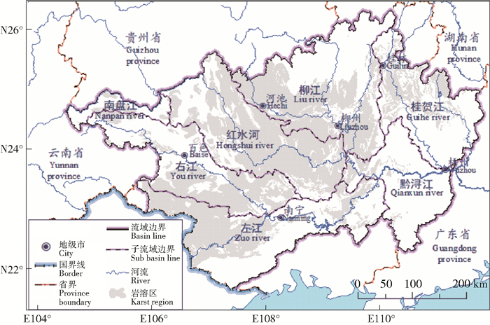
1 研究区概况西江流域位于广西壮族自治区境内珠江水系中上游地区, 地处E 104°28′~112°05′, N 21°35′~26°20′(图 1)。流域总面积约20万3 760 km2, 岩溶区面积约9万1 239 km2, 占流域总面积的44.78%。流域地貌类型多样, 以峰林、峰丛洼地、峰丛谷地等岩溶地貌为主, 地势表现为西北高东南低。西江流域位于中国西南部亚热带季风气候区, 常年高温多雨, 年降水量达1 080~2 760 mm, 岩溶作用强烈, 水土流失严重, 形成较大规模的石漠化土地。

|
图 1 研究区概况 Fig. 1 Schematic map of the studied area |
笔者选取2001、2006、2011和2016年4期MODIS NDVI遥感影像, 该数据为16 dNDVI合成产品, 空间分辨率250 m, 数据来源于美国NASA的MODIS Land products MODBQ1(https://ladsweb.modaps.eosdis.nasa.gov), 时相选择植被生长较为旺盛的5—9月, 即每年的第129、145、161、177、193、209、225、241、257和273天, 4期数据共80幅。此外, 还使用了《广西省区域地质图》《2010年广西土地利用图》《广西省地貌图》和30 m分辨率数字高程模型(SRTM DEM)等相关辅助数据。其中30 m分辨率SRTM DEM来源于地理空间数据云(http://www.gscloud.cn/)。
2.2 数据处理借助ArcGIS 10.1对MODIS NDVI影像进行拼接、裁剪及投影转换。采用最大值合成法(MVC)取4期数据各时段影像的NDVI最大值, 以进一步消除云、大气、太阳辐射的部分影响。在以上数据预处理基础上, 以ENVI 5.1为操作平台, 基于相元二分模型[7], 定量估算西江流域植被覆盖度(fractional vegetation coverage, FVC), 构建模型的过程中, 计算影像NDVI的积累频率, 选取积累比例0.5%为置信度, 其中积累比例>99.5%的为全植被覆盖, 积累<0.5%为全土壤覆盖。
2.3 石漠化等级划分与解译基于人机交互的石漠化解译方法[8-9], 以植被覆盖度为底图, 辅以地质图、地貌图、土地利用图及坡度图等相关数据, 借助ArcGIS 10.1进行综合叠加分析, 提取广西西江流域2001、2006、2011和2016年石漠化信息, 其中坡度图由30 m分辨率SRTM DEM换算得到。解译过程中, 参考前人以植被覆盖度划分石漠化等级的方法[10-11], 将其分为重度石漠化(FVC < 30%)、中度石漠化(30% < FVC < 50%)、轻度石漠化(50% < FVC < 70%)及无石漠化(FVC>70%)。
3 结果与分析 3.1 石漠化变化特征遥感监测数据(表 1)表明:2001、2006、2011和2016年广西西江流域石漠化面积分别占流域总面积的18.06%、15.58%、12.05%和7.34%。2001—2006年间轻度石漠化面积减少12.53%, 中度石漠化面积减少23.04%, 重度石漠化面积减少9.07%;2006—2011年间轻度石漠化面积减少22.17%, 中度石漠化面积减少28.21%, 重度石漠化面积减少12.16%;2011—2016年间轻度石漠化面积减少39.68%, 中度石漠化面积减少38.08%, 重度石漠化面积减少13.97%。表明近15年来石漠化土地面积持续缩减, 其缩减速率呈现出逐年增长的趋势。
| 表 1 西江流域2001—2016年各等级石漠化面积 Tab. 1 Area of rocky desertification in the Xijiang River Basin during 2001-2006 |
不同等级的石漠化面积由大到小排序为轻度石漠化(6.41%~15.61%)>中度石漠化(0.75%~2.19%)>重度石漠化(0.18%~0.27%), 表明石漠化面积随等级的升高而逐步减少, 石漠化等级结构呈现出明显的金字塔状。
3.2 石漠化的区域差异基于子流域尺度统计广西西江流域4期石漠化面积平均值(表 2), 统计结果表明:石漠化集中分布于西江流域中部及西部地区的红水河、柳江、右江及左江流域, 4个子流域的石漠化面积总和约占全区石漠化总面积的87.72%, 是石漠化问题较为严重的区域, 其中轻度石漠化面积占全区石漠化总面积的比例分别为29.36%、18.29%、15.15%和15.00%, 中度石漠化面积占比分别为2.44%、2.00%、1.76%和2.41%, 重度石漠化面积占比分别为0.27%、0.44%、0.20%和0.38%。
| 表 2 各子流域石漠化平均面积 Tab. 2 Average area of rocky desertification in each sub-basin |
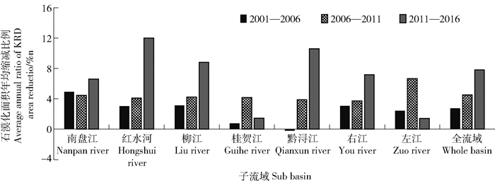
计算不同时段流域石漠化面积动态度(图 2), 结果表明:红水河、柳江、黔浔江及右江流域石漠化缩减速率的变化趋势与全流域一致, 2001—2006年间4个子流域石漠化年均缩减速率仅为3.03%、3.12%、-0.19%和3.05%, 而在2011—2016年间分别增长到12.01%、8.81%、10.62%和7.71%。南盘江流域石漠化缩减速率在最初10年内由4.94%下降至4.47%, 而在2011—2016年间石漠化缩减速率又上升至6.61%。桂贺江与左江流域石漠化缩减速率在2006—2011年间达到最大值, 而后又呈下降趋势变化。

|
图 2 子流域石漠化面积的缩减速率 Fig. 2 Reduction rate of the rocky desertification area in each sub-basin |
在GIS技术的支持下, 将2001、2006、2011和2016年广西西江流域石漠化图进行综合叠加分析, 统计石漠化变差状况, 分析石漠化演变规律。
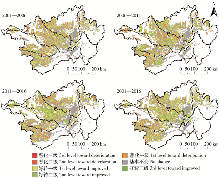
分析结果(图 3)表明石漠化演变是不同等级石漠化相互转移的动态过程。石漠化转移主要集中在较低等级石漠化之间, 其中无石漠化与轻度石漠化之间的面积相互转移量最大, 在2001—2006、2006—2011和2011—2016年3个时段内其面积转移量占总转移量的比例分别达到78.82%、81.68%和84.55%;相邻等级石漠化的面积相互转移量较大, 不同等级石漠化之间面积跳跃转移的转移量较小, 从整体上看, 2001—2016年间相邻等级的石漠化面积转移量占总转移量的比例达94.68%, 石漠化跨等级的转移量仅占总转移量的5.32%。另外, 重度石漠化转移面积最小, 其面积转移量仅占总转移量的2.01%, 说明重度石漠化治理难度大, 治理措施在短期内难见显著成效。

|
图 3 广西西江流域2001—2016年石漠化动态变化 Fig. 3 Dynamic characteristic of rocky desertification of Xijiang River Basin during 2001-2016 |
近15年间, 伴随着石漠化综合治理措施的开展与石漠化区土地压力的缓解, 西江流域石漠化面积呈加速趋势缩减。当前, 广西省针对境内石漠化防治问题已开展了大量的实验与研究[12-13]。截止至2014年, 广西省已有75个石漠化严重县被纳入以小流域为单元的石漠化综合治理工程建设范围, 配合当前国家新农村建设政策, 着力打造以石漠化区生态恢复为目标, 有机结合耕作、农业、工程和管理的石漠化综合治理方案[12], 多项治理措施的综合作用使得石漠化区植被得到有效恢复。另外, 人口外迁与生态移民等活动在一定程度上缓解了岩溶区的土地压力, 第5次人口普查数据表明[14], 广西省迁移人口占全区总人口数的7.99%, 人口迁移方向主要由乡镇地区指向经济发达的城市地区, 大规模的人口迁移为迁出地的生物栖息与繁衍提供更为广阔的空间, 也避免了毁林开荒、陡坡开荒等不合理人类活动的影响, 减轻了水土流失与土地退化的风险, 使得迁出地的生态环境得到有效的恢复与保护[15]。一般认为石漠化的形成受其岩性特征、地貌形态、气候类型、植被状况等因素的控制, 并在不合理的人类活动的影响下进一步恶化[16]。广西西江流域石漠化主要分布于流域中部及西部地区, 从自然环境因素上看, 一方面西江流域中部及西部岩溶区面积广阔, 空间分布连续, 加之该地区海拔相对较高, 坡度较大, 且处于西南季风的迎风坡, 雨季降水量大, 导致该地区土壤侵蚀现象明显, 另一方面, 流域岩溶区植被类型多为灌木, 许多地区植被群落未达到顶级[17]; 因此在极端气候与人为因素的干扰下发生石漠化。从社会经济因素上看, 红水河、柳江、左江及右江流域岩溶区是广西省贫困人口的主要集中地, 人口密度较大, 如大化、马山、平果等县级市, 人口密度高达150人/km2, 严重超过了岩溶区的环境负荷[3], 不合理及过度的开荒活动加剧了当地的水土流失, 进而提高了石漠化形成与演化的速度。
石漠化的演化过程同时存在好转与恶化2个方向。石漠化转移主要集中于较低等级的石漠化之间, 且相邻等级石漠化转移量远大于跨等级石漠化转移量, 表明石漠化演化是一个渐变的过程, 低等级石漠化相比于高等级石漠化更容易发生改变, 这与陈起伟等[9]针对贵州省石漠化的监测结果一致。等级较高的石漠化地区, 由于其岩石裸露率过高, 土被覆盖少, 土壤浅薄, 使得该区已经恶化的生态系统难以得到恢复[18]。也有研究表明裸岩率与坡地的微地貌部位关系密切, 坡丘上部相较于坡低具有较高的裸岩率[19], 尤其是坡丘顶部, 一般无路可通, 因此对该地区进行综合治理是难上加难, 只能等待其进行漫长的自我恢复。而石漠化程度较轻的地区, 其土壤覆盖状况相对较好, 并且该区域具有一定的通达性, 具有相对较好的治理条件, 所以这些地区的石漠化状况更容易在人类的合理干涉下得到改善。
5 结论基于2001、2006、2011和2016年4期MODIS NDVI影像数据, 以广西西江流域为研究单元, 提取广西西江流域石漠化空间信息, 分析广西西江流域石漠化动态变化特征。主要结论如下:
1) 2001、2006、2011和2016年广西西江流域石漠化面积分别占流域总面积的18.06%、15.58%、12.05%和7.34%, 流域石漠化面积呈现出随等级增加而降低的金字塔结构; 近15年间, 在多项石漠化综合治理工程广泛实施的背景下, 广西西江流域石漠化土地面积持续下降, 且降幅逐年增加。
2) 石漠化集中分布于西江流域中部及西部地区, 其中红水河、柳江、左江及右江4个子流域石漠化面积占全流域石漠化面积的87.72%。红水河、柳江、黔浔江及右江流域石漠化缩减速率的变化趋势同全流域基本一致, 桂贺江与左江流域石漠化缩减速率呈先增后减的趋势变化, 在2006—2011年间达到最大值, 分别为4.18%和6.68%。
3) 石漠化面积变化同时存在好转与恶化2个方向, 低等级石漠化相比于高等级石漠化更容易向相邻等级石漠化转移。在本研究时段内, 石漠化转移呈现高等级石漠化逐步向低等级石漠化转变的特征, 表明针对广西西江流域石漠化的治理已取得一定成效, 但部分地区石漠化问题依然存在, 还需要进一步加强流域石漠化监测力度, 及时调整与优化石漠化综合治理措施。
| [1] |
李森, 董玉祥, 王金华. 土地石漠化概念与分级问题再探讨[J].
中国岩溶, 2007, 26(4): 279.
LI Sen, DONG Yuxiang, WANG Jinhua. Re-discussion on the concept and classification of rocky desertification[J]. Carsologica Sinica, 2007, 26(4): 279. DOI: 10.3969/j.issn.1001-4810.2007.04.001. |
| [2] |
喻甦. 中国石漠化分布现状与特点[J].
中南林业调查规划, 2003, 22(2): 53.
YU Su. The present situation and characteristics of rocky desertification in China[J]. Central South Forest Inventory and Planning, 2003, 22(2): 53. DOI: 10.3969/j.issn.1003-6075.2003.02.017. |
| [3] |
胡业翠, 方玉东, 江文亚. 广西喀斯特石漠化与贫困化空间相关性及互动效应研究[J].
资源与产业, 2009, 11(5): 105.
HU Yecui, FANG Yudong, JIANG Wenya. Spatial correlation and interaction between rocky desertification and poverty in karst mountainous area in Guangxi[J]. Resources & Industries, 2009, 11(5): 105. |
| [4] |
李彬. 中国南方岩溶区环境脆弱性及其经济发展滞后原因浅析[J].
中国岩溶, 1995, 14(3): 209.
LI Bin. An elementary analysis to environment fragility and reasons for economics lagging in the karst area of South China[J]. Carsologica Sinica, 1995, 14(3): 209. |
| [5] |
刘芳, 何报寅, 寇杰锋. 利用Landsat热红外遥感调查广西平果县石漠化现状和变化特征[J].
中国水土保持科学, 2017, 15(2): 125.
LIU Fang, HE Baoyin, KOU Jiefeng. Landsat thermal remote sensing to investigate the present situation and variation characteristics of karst rocky desertification in Pingguo county of Guangxi, Southwest China[J]. Science of Soil and Water Conservation, 2017, 15(2): 125. |
| [6] |
申文辉. 广西石漠化综合治理研究进展及展望[J].
广西林业科学, 2014, 43(4): 395.
SHEN Wenhui. Research progress and prospects of rocky desertification comprehensive treatment in Guangxi[J]. Guangxi Forestry Science, 2014, 43(4): 395. DOI: 10.3969/j.issn.1006-1126.2014.04.009. |
| [7] |
龙晓闽, 周忠发, 张会, 等. 基于NDVI像元二分模型植被覆盖反演喀斯特石漠化研究:以贵州毕节鸭池示范区为例[J].
安徽农业科学, 2010, 38(8): 4184.
LONG Xiaomin, ZHOU Zhongfa, ZHANG Hui, et al. Study on karst rock-desertification of extracting vegetation coverage inversion based on NDVI serial images and dimidiate pixel model[J]. Journal of Anhui Agricultural Science, 2010, 38(8): 4184. DOI: 10.3969/j.issn.0517-6611.2010.08.129. |
| [8] |
王晓燕, 徐志高. 基于RS与GIS的岩溶区石漠化时空变化特征:以湖南省慈利县为例[J].
水土保持研究, 2008, 15(5): 7.
WANG Xiaoyan, XU Zhigao. Spatial and temporal variation features of rocky-desertification in karst area based on RS and GIS technology[J]. Research of Soil and Water Conservation, 2008, 15(5): 7. |
| [9] |
陈起伟, 熊康宁, 兰安军. 基于3S的贵州喀斯特石漠化遥感监测研究[J].
干旱区资源与环境, 2014, 28(3): 62.
CHEN Qiwei, XIONG Kangning, LAN Anjun. Monitoring studies on karst rocky desertification in Guizhou based on 3S[J]. Journal of Arid Land Resources and Environment, 2014, 28(3): 62. DOI: 10.3969/j.issn.1003-7578.2014.03.011. |
| [10] |
张文源, 王百田. 贵州喀斯特石漠化分类分级探讨[J].
南京林业大学学报, 2015, 39(2): 148.
ZHANG Wenyuan, WANG Baitian. Discussion on classification and gradation of karst rocky desertification in Guizhou province[J]. Journal of Nanjing Forestry Unibersity, 2015, 39(2): 148. |
| [11] |
周忠发. 遥感和GIS技术在贵州喀斯特地区土地石漠化研究中的应用[J].
水土保持通报, 2001, 21(3): 52.
ZHOU Zhongfa. Application of remote sensing and GIS technology for land desertification in Guizhou karst region[J]. Bulletin of Soil and Water Conservation, 2001, 21(3): 52. DOI: 10.3969/j.issn.1000-288X.2001.03.014. |
| [12] |
邓艳, 曹建华, 蒋忠诚, 等. 西南岩溶石漠化综合治理水-土-植被关键技术进展与建议[J].
中国岩溶, 2016, 35(5): 476.
DENG Yan, CAO Jianhua, JIANG Zhongcheng, et al. Advancement in key technologies for comprehensive treatment of water, soil and vegetation resources in karst rocky desertification areas[J]. Carsologica Sinica, 2016, 35(5): 476. |
| [13] |
关键超, 覃伟良, 陈丽, 等. 广西岩溶地区石漠化动态变化及林业防治措施[J].
安徽农业科学, 2017, 45(3): 187.
GUAN Jianchao, QIN Liangwei, CHEN Li, et al. Discussion on forestry measures and trend analysis of rocky desertification in Guangxi[J]. Journal of Anhui Agricultural Science, 2017, 45(3): 187. DOI: 10.3969/j.issn.0517-6611.2017.03.062. |
| [14] |
周鸿. 从广西第五次人口普查看人口迁移状况[J].
广西师范大学学报, 2004, 25(3): 147.
ZHOU Hong. An analysis of the migration of the fifth Guangxi population survey[J]. Journal of Guangxi Normal University, 2004, 25(3): 147. |
| [15] |
蔡林. 人口迁移和流动对生态环境的有利影响分析[J].
生态经济, 2006(6): 44.
CAI Lin. The beneficial influence of population migration & flow on the ecosystem of environment[J]. Ecological Economy, 2006(6): 44. DOI: 10.3969/j.issn.1671-4407.2006.06.010. |
| [16] |
周锦忠, 吕英娟. 石漠化的成因机理与防治对策[J].
国土资源导刊, 2003, 22(1): 43.
ZHOU Jinzhong, LÜ Yingjuan. Discussion on the origin, mechanism, prevention, management of becoming rock desert[J]. Land and Resources Herald, 2003, 22(1): 43. DOI: 10.3969/j.issn.1672-5603.2003.01.010. |
| [17] |
李先琨, 苏宗明, 吕仕洪, 等. 广西岩溶植被自然分布规律及对岩溶生态恢复重建的意义[J].
山地学报, 2003, 21(2): 129.
LI Xiankun, SU Zongming, LÜ Shihong, et al. The spatial pattern of natural vegetation in the karst regions of Guangxi and the ecological signality for ecosystem rehabilitation and reconstruction[J]. Journal of Mountain Science, 2003, 21(2): 129. DOI: 10.3969/j.issn.1008-2786.2003.02.001. |
| [18] |
宋同清, 彭晚霞, 杜虎, 等. 中国西南喀斯特石漠化时空演变特征、发生机制与调控对策[J].
生态学报, 2014, 34(18): 5328.
SONG Tongqing, PENG Wanxia, DU hu, et al. Occurrence, spatial-temporal dynamics and regulation strategies of karst rocky desertification in southwest China[J]. Acta Ecologica Sinica, 2014, 34(18): 5328. |
| [19] |
邱虎森, 苏以荣, 黎蕾, 等. 典型喀斯特高原坡地土壤养分分布及其影响因素[J].
土壤, 2013, 45(6): 985.
QIU Husen, SU Yirong, LI Lei, et al. Distribution of soil nutrients and its influencing factors in slope of typical Karst plateau[J]. Soils, 2013, 45(6): 985. |