2. 宁夏盐池毛乌素沙地生态系统国家定位观测研究站, 751500, 宁夏盐池
-
项目名称
- 林业公益性行业科研专项经费资助项目"青藏铁路沿线沙害综合防治技术研发与示范"(201504401)
-
第一作者简介
- 赵洋(1993-), 男, 硕士研究生。主要研究方向:荒漠化防治。E-mail:zhaoyang2015@bjfu.edu.cn
-
通信作者简介
- 高广磊(1986-), 男, 博士, 讲师。主要研究方向:水土保持与荒漠化防治。E-mail:gaoguanglei@bjfu.edu.cn
-
文章历史
-
收稿日期:2017-05-10
修回日期:2017-07-03
2. 宁夏盐池毛乌素沙地生态系统国家定位观测研究站, 751500, 宁夏盐池
2. Yanchi Ecology Research Station of the Mu Us Desert, 751500, Yanchi, Ningxia, China
青藏铁路东起青海西宁,西至西藏拉萨,全长1956km,是世界海拔最高、线路最长的高原铁路,是连接西藏与内地的重要线路,也是我国西部大开发战略的标志性工程;但是,青藏铁路途经青藏高原高寒沙区,沿线风沙活动强烈,沙埋铁轨、风蚀路基和磨蚀设备等风沙灾害对青藏铁路安全运行造成严重威胁[1-3],因此,青藏铁路沿线风沙灾害防治得到了全国乃至世界范围的热切关注[2]。
经过几十年的努力,青藏铁路一期工程西宁至格尔木段风沙灾害已经得到有效控制[2-3]。目前,风沙灾害主要集中在二期工程格尔木至拉萨段,特别是南山口、红梁河、秀水河、北麓河、沱沱河、唐南至扎加藏布和错那湖等地段[4-7]。为缓解风沙灾害威胁,青藏铁路沿线重点沙害路段布置了大规模且种类多样的工程治沙措施[8];但目前,上述措施仍缺乏系统的科学评价,部分风沙灾害路段防护体系布设存在一定缺陷[8-9]。
南山口是青藏铁路二期工程的起点,距格尔木市约30km,是青藏铁路重点风沙灾害路段之一。鉴于此,本研究基于对南山口段风沙灾害防护体系的野外调查,开展风洞模拟实验,旨在科学评价和系统优化南山口段风沙灾害防护体系,并为构建科学高效的青藏铁路风沙灾害防护体系提供理论依据和科技支撑。
1 研究区概况研究区位于青藏铁路二期工程南山口段,地处柴达木盆地南缘山前冲积洪积倾斜平原,属典型的高原大陆性气候区。研究区常年干燥少雨,年均降水量42.2mm。南山口是青藏铁路沿线扬沙和沙尘暴天气的多发路段,这一地区盛行西风,盛行风向与南北走向的铁路线路近似垂直,年均风速2.2m/s,年平均大风时间约为16d,但多集中于3—6月[10]。研究区具有鲜明的戈壁荒漠地貌景观,地势平坦,土壤结构松散,土壤质量较差,为土壤风蚀的发生发展提供了丰富的物质基础。该区域植被稀少,植被类型以旱生灌木和小半灌木为主,植被组成单一,植株低矮且生长稀疏[11]。受恶劣的自然条件限制,风沙灾害防治生物措施难以在南山口地区大面积实施,因此,南山口地区布设了大规模的风沙灾害防治工程措施。
2 研究方法 2.1 野外调查2016年7月,在青藏铁路南山口段开展野外调查,调查内容主要包括路域风沙灾害防护体系的布设格局、工程措施材料与规格、铁路路基参数,并采用断面测量的方法对风沙灾害防护体系内的积沙量进行测定[12]。
2.2 风洞模拟实验2016年9月,在北京林业大学风沙物理实验室开展风洞模拟实验。风洞全长24.5m,试验段长12m,试验段横截面积为0.6m × 0.6m,实用风速3~40m连续可调。依据南山口风信资料,将实验风速设定为15m/s。风向与路基方向垂直,模型比例尺1:50。使用三维移测系统和KIMO热线风速仪观测风速,每个风速测点的测量时间为20s,取风速平均值。主要实验内容如下:1)铁路路基风速流场特征:将铁路路基模型放置于风洞试验段,通过三维移测系统调整风速仪探头的位置,测绘路基周边流场分布;2)工程防护措施防护效果评价:将工程防护措施及铁路路基模型放置于风洞试验段,观测工程防护措施周围流场特征,以及防护措施对路基周边流场的影响。
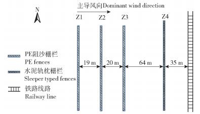
3 结果与讨论 3.1 风沙灾害防护体系布置格局与积沙特征青藏铁路南山口段风沙灾害防护体系包括3道PE网栅栏和1道轨枕栅栏,总长度138m(图 1)。其中:PE网栅栏位于防护体系最外侧,高160cm,孔隙度约为40%,间距分别为19和20m;轨枕栅栏在防护体系内侧,高210cm,孔隙度约为15%,分别距PE网栅栏和铁路路基64和35m。
|
图 1 青藏铁路南山口段风沙灾害防护体系 Fig. 1 Control measures of wind-sand disaster in the Nanshankou section of the Qinghai-Tibet railway |
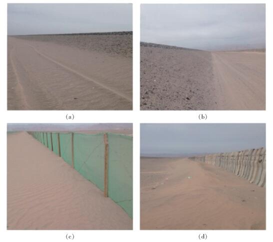
在无防护体系保护的区域,路基迎风侧坡脚存在积沙(图 2(a)),路基背风侧坡脚则无积沙现象。在受到防护体系保护的区域,积沙主要分布在阻沙栅栏周围,路基周围则不存在积沙现象(图 2(b))。其中:PE网栅栏的积沙较为均匀的分布在栅栏背风侧,积沙体断面近似于三角形(图 2(c));轨枕栅栏两侧都有积沙,其背风侧积沙体呈沙脊断面结构(图 2(d))。各阻沙栅栏内积沙量差异较大,轨枕栅栏Z4的积沙量最多,占总积沙量的73.42%;PE网栅栏Z2次之,占总积沙量的23.74%;PE网栅栏Z2和Z3的积沙量较少,仅占总积沙量的2.42%和0.42%。因此,轨枕栅栏Z4积沙压力较大,而PE网栅栏Z2和Z3并未充分发挥阻沙功能。这增加了铁路沙害风险,降低了轨枕栅栏Z4的使用年限,且增加了人工清沙和更新沙障的成本。
|
图 2 青藏铁路南山口段积沙情况 Fig. 2 Sand deposition in the Nanshankou section of the Qinghai-Tibet railway |
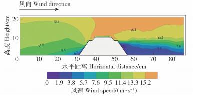
由图 3可知,气流在途径铁路路基的过程中存在着明显的功能分区。气流在接近路基时发生遇阻抬升,在路基迎风侧前方形成遇阻抬升区。气流继续前进至路基附近时,在路基迎风侧坡脚形成减速沉降区。而后,气流沿路基迎风侧表面运动,并明显出现加速过程,迎风面流速最大值位于迎风侧路肩,可达14.2m/s。此后,气流不断在路基顶部汇集,形成集流加速区,流速达到极大值16.5m/s,而此时对应高度的来流速度仅为12.0m/s。通过路基顶部后,气流呈现减速趋势,且在路基背风侧距地表 8cm以下区域减速尤为明显,形成减速沉降区。在距地表 8cm以上的区域,虽然气流流速仍高于相同高度的来流速度,但气流速度仍始终保持减速趋势,最终形成恢复消散区。
|
图 3 青藏铁路南山口段铁路路基流场分布 Fig. 3 Flow fileds around railwaybed in the Nanshankou section of the Qinghai-Tibet railway |
南山口段铁路路基流场特征表明,铁路路基对于风速流场有明显影响。在没有风沙灾害防护体系的情况下,由于路基迎风侧和背风侧减速沉降区的存在,风沙流中的沙粒会在铁路路基两侧坡脚附近沉降,在弱风条件下可使铁路遭受到沙埋,路基顶部的集流加速区则会造成迎风侧路肩发生风蚀破坏。
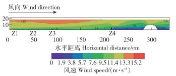
3.3 风沙灾害防护体系流场特征南山口段风沙灾害防护体系流场分布如图 4所示。当气流运动至PE网栅栏Z1前时,栅栏高度范围内气流流速缓慢降低,但在栅栏前并未形成明显的弱风区。与PE网栅栏Z1情况相似,PE网栅栏Z2及Z3障前和障后的风速变化较小。气流通过均匀透风的PE网栅后,风速并未迅速降低,而是随着距离的增长持续降低,进而在栅栏背风侧形成流线变化缓慢且范围较大的弱风区;故PE网栅栏附近的积沙主要出现在背风侧,且分布较均匀,积沙体呈现出近似狭长三角形的积沙断面。在PE网栅栏Z3后约60cm开始,栅栏高度范围的气流基本呈现出稳定趋势。
|
图 4 青藏铁路南山口段防护体系流场分布 Fig. 4 Flow fields around wind-sand disaster control measures in the Nanshankou section of the Qinghai-Tibet railway |
当气流运动至轨枕栅栏Z4附近后,其流速变化过程与在PE网栅栏附近的变化过程区别明显。在轨枕栅栏Z4前约6cm处,气流流速开始大幅降低,在栅栏前形成明显的弱风区。气流在途经轨枕栅栏Z4时抬升明显,其上方气流受到挤压,流线密集,流速增大。同时,由于轨枕间存在上窄下宽的狭长缝隙,这使距地面3cm高度以下,穿过栅栏的气流在短距离内先加速后减速,在背风侧形成涡流区;因此,轨枕栅栏Z4的迎风侧和背风侧都存在积沙现象,且背风侧积沙体具有沙脊断面结构。
南山口段风沙灾害防护体系对路基周边风速存在显著影响(图 3和图 4)。在防护体系的保护下,路肩风速由无防护体系时的15.1m/s降为11.9m/s;因此,防护体系不仅具有拦截风沙流中沙物质的作用,还降低了路肩风蚀的可能性。但仅有的一道轨枕栅栏承担了73.42%的阻沙量,其积沙压力过大,且距铁路仅35m,存在危害铁路运行的潜在风险。
3.4 风沙灾害防护体系优化目前,青藏铁路南山口段风沙灾害防护体系的宽度仅为138m,且沙物质大量沉积于距铁路路基仅有35m的轨枕栅栏Z4处,铁路安全运行面临风沙灾害风险的严重威胁;同时,由于南山口区域地表覆盖大量砾石,戈壁地貌特征明显,区域内“就地起沙”的现象并不明显,危害铁路的沙源主要来自于周边区域的流动和半流动沙丘[13]:因此,建议在南山口段风沙灾害防护体系的上风向增设不透风或致密的高立式沙障,将防护体系宽度增加至300~500m,以利于拦截外部的风沙流,将沙物质沉积在防护体系外缘,远离铁路,保障铁路的安全运行[14]。
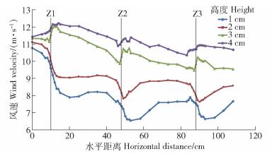
现阶段,3道PE网栅栏积沙量差异较大,PE网栅栏Z2和Z3未能充分发挥防风阻沙功能。风洞中3道PE网栅栏前后风速变化情况如图 5所示。风沙流在PE网栅栏Z1处遇阻,风速呈降低趋势,风沙流中的沙物质发生堆积现象。而后,风沙流按由下至上的空间层次风速逐渐回升,风沙流携沙能力提高,沙物质不再沉降。在PE网栅栏Z2和Z3处,风沙流风速变化趋势与PE网栅栏Z1处基本一致,PE网栅栏Z2和Z3并未进一步削弱风速,阻截风沙流中的沙物质;因此,风沙流在通过3道PE网栅栏时风速呈波动下降趋势,且减速过程主要发生在PE网栅栏Z1处,PE网栅栏Z2和Z3的防风阻沙功能并未充分发挥。鉴于此,建议缩短PE网栅栏的间距,以利于持续降低风速,增强PE网栅栏的阻沙效果。
|
图 5 PE网栅栏前后风速变化 Fig. 5 Variation in wind velocity around PE fences |
1) 青藏铁路南山口段盛行西风,南北走向的铁路路基成为阻碍风沙运动的障碍物。路基坡脚低速区造成路基坡脚积沙,路肩和道床的集流加速区则有风蚀路基和磨蚀的危险。
2) 在南山口段风沙灾害防护体系中,轨枕栅栏防风阻沙的效果较好, 但其积沙压力过大且与铁路距离过近,存在危害铁路运行的潜在风险。第2、3道PE网栅栏未充分发挥阻沙功能,增大了轨枕栅栏的积沙压力。
3) 建议在铁路上风向增设紧密或不透风的高立式沙障,使防护体系宽度增加至300~500m,将沙物质阻截在防护体系外缘。同时,缩短3道PE网栅栏间距以持续降低风速,增强其阻沙效果。
| [1] |
谢胜波, 屈建军. 青藏铁路主要沙害路段治理技术及成效[J].
干旱区资源与环境, 2014, 28(7): 105.
XIE Shengbo, QU Jianjun. Sand damage control and effect at main sections of Qinghai-Tibet railway[J]. Journal of Arid Land Resources and Environment, 2014, 28(7): 105. |
| [2] |
LIU Zhimin, ZHAO Wenzhi. Shifting-sand control in central Tibet[J].
Ambio, 2015, 30(6): 376.
|
| [3] |
ZHANG Kecun, QU Jianjun, LIAO Kongtai, et al. Damage by wind-blown sand and its control along Qinghai-Tibet railway in China[J].
Aeolian Research, 2010, 1(3/4): 143.
|
| [4] |
谢胜波, 屈建军, 刘冰, 等. 青藏铁路沙害及其防治研究进展[J].
中国沙漠, 2014, 34(1): 42.
XIE Shengbo, QU Jianjun, LIU Bing, et al. Advances on research on the sand hazards and its controls along the Qinghai-Tibet railway[J]. Journal of Desert Research, 2014, 34(1): 42. |
| [5] |
XIE Shengbo, QU Jianjun, XU Xiangtian, et al. Interactions between freeze-thaw actions, wind erosion desertification, and permafrost in the Qinghai-Tibet Plateau[J].
Natural Hazards, 2017, 85(2): 829.
DOI: 10.1007/s11069-016-2606-4. |
| [6] |
ZHANG Kecun, QU Jianjun, NIU Qinghe, et al. Characteristics of wind-blown sand and dynamic environment in the section of Wudaoliang-Tuotuo River along the Qinghai-Tibet Railway[J].
Environmental Earth Sciences, 2011, 64(8): 2039.
|
| [7] |
XIE Shengbo, QU Jianjun, LAI Yuanming, et al. Formation mechanism and suitable controlling pattern of sand hazards at Honglianghe River section of Qinghai-Tibet Railway[J].
Natural Hazards, 2015, 76(2): 855.
|
| [8] |
XIAO Jianhua, YAO Zhengyi, QU Jianjun. Influence of Golmud-Lhasa Section of Qinghai-Tibet Railway on blown sand transport[J].
Chinese Geographical Science, 2015, 25(1): 39.
DOI: 10.1007/s11769-014-0722-1. |
| [9] |
牛清河, 屈建军, 张克存, 等. 青藏铁路典型路段风沙灾害现状与机械防沙效益估算[J].
中国沙漠, 2009, 29(4): 596.
NIU Qinghe, QU Jianjun, ZHANG Kecun, et al. Status of aeolian-sand disaster and estimation of mechanical sand-controlling benefit at typical sections of Qinghai-Tibet Railway[J]. Journal of Desert Research, 2009, 29(4): 596. |
| [10] |
白虎志, 李栋梁, 董安祥, 等. 青藏铁路沿线的大风特征及风压研究[J].
冰川冻土, 2005, 27(1): 111.
BAI Zhihu, LI Dongliang, DONG Anxiang, et al. Strong wind and wind pressure along the Qinghai-Tibet Railway[J]. Journal of Glaciology and Geocryology, 2005, 27(1): 111. DOI: 10.3969/j.issn.1000-0240.2005.01.017. |
| [11] |
ZHOU Jinxing, YANG Jun, PENG Gong. Constructing a green railway on the Tibet Plateau:Evaluating the effectiveness of mitigation measures[J].
Transportation Research Part D Transport & Environment, 2008, 13(6): 369.
|
| [12] |
姜鑫贵, 周金星, 刘玉国, 等. 青藏铁路南山口段沙害防治措施的效果[J].
林业科学, 2016, 52(10): 55.
JIANG Xingui, ZHOU Jinxing, LIU Yuguo, et al. Effectiveness of sand control measures in Nanshankou Area along Qinghai-Tibet Railway[J]. Scientia Silvae Sinicae, 2016, 52(10): 55. DOI: 10.11707/j.1001-7488.20161007. |
| [13] |
范基姣, 谭立渭, 佟元清. 青藏铁路沿线格尔木-南山口段环境地质评价[J].
中国人口·资源与环境, 2011, 21(3): 288.
FAN Jijiao, TAN Liwei, TONG Yuanqing. Environmental geology assessment of Qinghai-Tibet railway from golmud to south mountains pass using AHP-FUZZY method[J]. China Population, Resources and Environment, 2011, 21(3): 288. |
| [14] |
谢胜波, 屈建军, 刘冰, 等. 青藏铁路沙害及其防治研究进展[J].
中国沙漠, 2014, 34(1): 42.
XIE Shengbo, QU Jianjun, LIU Bing, et al. Advances in research on the sand hazards and its controls along the Qinghai-Tibet railway[J]. Journal of Desert Research, 2014, 34(1): 42. |
 2018, Vol. 16
