2. 江西农业大学国土资源与环境学院, 330045, 南昌
-
项目名称
- 国家自然科学基金"基于3D激光扫描技术的风化花岗岩崩岗侵蚀泥沙来源空间分布研究"(41301301);广东省水利科技创新项目"三维激光扫描技术在广东崩岗侵蚀监测中的应用研究"(2012-14);广东省科学院实施创新驱动发展能力建设专项资金项目"地理科技创新与产业化应用能力建设"(2017GDASCX-0101)
-
第一作者简介
- 温美丽(1976-), 女, 博士, 副研究员。主要研究方向:土壤侵蚀与水土保持。E-mail:wenml@gdas.ac.cn
-
文章历史
-
收稿日期:2016-11-17
修回日期:2018-05-10
2. 江西农业大学国土资源与环境学院, 330045, 南昌
2. School of Land and Resources and the Environment, Jiangxi Agriculture University, 330045, Nanchang, China
崩岗是我国南方丘陵地区普遍存在的严重水土流失类型,它是由水力与重力联合作用形成的特殊地貌类型。崩岗侵蚀产生的大量泥沙会掩埋良田、阻塞河道,对下游人民的生命安全及生产活动造成严重威胁,并造成巨额经济损失[1]。我国崩岗主要分布于湖北、湖南、安徽、江西、福建、广东、广西等7个省区。2005年水利部调查结果显示,南方7省区崩岗总数共24万个,土壤侵蚀面积达到1 200多km2,年侵蚀量6 000万t,对山下影响范围近200万hm2[2]。
“崩岗”一词由曾昭璇①在1960年率先引入到地貌学,它揭示了崩岗的侵蚀方式和侵蚀后的地貌特征,具有发生学与形成学的双重含义[3-4]。学者们50多年的研究,集中在地质母岩、降雨、植被、坡向等诸多因素对崩岗侵蚀的影响[5]。
① 曾昭璇.地形学原理(第一册)[M].华南师范学院地理丛书之二, 1960.
许多研究指出崩岗侵蚀的发育具有坡向选择性,但坡向划分方法差异较大,如南北坡崩岗分布研究中,南坡角度有的是8个坡向之一(180°±22.5°)[6-8],有的是16个坡向之一(180°±11.25°)[9]。阴阳坡崩岗分布研究中,南坡与阳坡存在3种关系:南坡等于阳坡[10]、阳坡包括南坡[1, 11-14]、南坡包括阳坡[15]。崩岗的坡向确定方法也存在差异,有的[13-14]用GIS方法统计坡向,大部分用人工方法。这些混乱导致学者们的研究结论虽表述一致,如崩岗分布数量在南坡②多于北坡[1, 6-11, 13],阳坡多于阴坡[1, 10-13];崩岗面积南坡多于北坡[6-7, 12],阳坡多于阴坡[12],但无法准确定量崩岗在不同坡向的分布规律,甚至会质疑崩岗坡向选择性结论的通用性和适用性[16]。
② 南坡,也称为向南坡或南向坡,阳坡也被称为向阳坡。
不同坡向提取方法、不同坡向划分标准对崩岗分布的坡向选择性有无影响?若已有研究使用相同坡向标准和统计方法,崩岗坡向选择性结论是否成立?不同坡向崩岗分布的定量关系如何?针对上述问题,本文开展试验研究,期望了解坡向的不同提取和划分方法对崩岗坡向研究的适宜性,验证崩岗坡向选择性的结论,明确崩岗坡向选择性的通用性和适用性,定量计算不同坡向的崩岗分布。研究结果将更加深入地揭示崩岗侵蚀发育的规律,可用于指导崩岗侵蚀的防治。
1 数据与方法 1.1 坡向的计算与分类崩岗的坡向角度通过2种方法计算得到。人工计算法是在纸质地形图上根据崩岗所处坡面的主坡向或所属山脉的走势确定崩岗的主方向,再根据水流的方向,确定崩岗的精确方向,手动测量方位角;GIS方法是利用ArcGIS软件通过面积加权确定每个崩岗的坡向角度数值。同时利用GIS方法计算油田镇域的土地坡向角度。
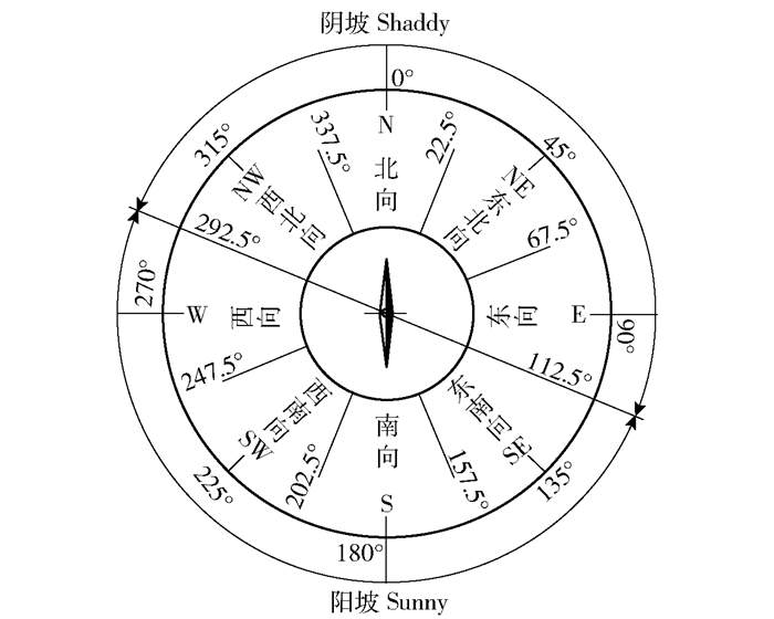
将得到的坡向角度,从0°±22.5°开始,顺时针每45°划分1个坡向,依次为北、东北、东、东南、南、西南、西、西北,得到8个方位(即8分法),该方法与ArcGIS系统中的坡向划分方法一致。在8分法基础上,一些研究[13-14]也采用3分法,将东南、南、西南称为阳坡,西北、北、东北称为阴坡,将东、西坡称为半阳坡。在水土保持监测和调查中常用坡向阴阳2分法,根据太阳入射角将北半球的东南坡、南坡、西南坡、西坡称为阳坡,将西北坡、北坡、东北坡、东坡称为阴坡[17],坡向的8分法、3分法和2分法的关系详见图 1。

|
图 1 坡向8分法和2分法的对应关系 Figure 1 Corresponding relationship between 8-slope-aspect and 2-slope-aspect |
数据来源包含2部分:1)1978年广东省梅州市五华县油田镇1:1万地形图和油田镇边界;2)已发表文献中的各坡向崩岗数据。
五华县位于广东东北部,韩江上游,是全国崩岗分布最密集的地区;油田镇位于五华县中东部,与兴宁市水口镇接壤。E 115°48′48″~115°55′16″,N 23°51′39″~23°58′37″,全镇土地总面积85.6 km2,土壤母质主要是深厚的花岗岩风化物。
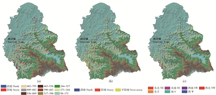
首先,借助ArcGIS软件数字化油田镇地形图的等高线、崩岗边界、油田镇边界等要素,根据3种坡向划分方法,计算并统计油田镇各坡向的土地面积、每个崩岗的坡向和面积,并制作崩岗的坡向分布图(图 2)。由于地形图比例尺所限,面积较小的崩岗在图上仅表示为一条线,无法统计面积,因此本文统计的崩岗不包含较小的崩岗。然后,将收集的已有崩岗坡向文献根据前文确定的坡向划分方法,重新统计各坡向崩岗的数量和面积,并计算数量和面积百分比。已有文献共计11篇,研究区分布在广东、福建和江西3省。所有数据使用Excel计算均值和标准差,用SPSS13.0进行方差分析,阴阳坡用t检验,方差分析中3分法用LSD事后检验,8分法用Tukey事后检验。

|
NE: Northeast E: East SE: Southeast S: South SW: Southwest W: West NW: Northwest 图 2 基于2分法(a)、3分法(b)和8分法(c)的油田镇崩岗坡向分布图 Figure 2 Distribution of collapsed gullies by 2-slope-aspect(a), 3-slope-aspect (b), and 8-slope-aspect (c) in Youtian town |
根据1:1万地形图利用ArcGIS计算得到,油田镇土地总面积为8 560.49 hm2,崩岗共计293个,崩岗总面积89.79 hm2,崩岗占全镇土地总面积的1.05%,平均每km2 3.4个崩岗,崩岗面积最小305 m2,最大17 065 m2,平均每个崩岗3 064 m2。根据油田镇各坡向面积分布统计(图 2):2分法中阳坡面积占44.2%,阴坡占55.8%;3分法中阳坡占31.2%,阴坡占45.5%;8分法中北坡面积最大,占19.4%,南坡仅占10.3%。因此油田镇阳坡土地面积大于阴坡,北坡土地面积大于南坡。
2.2 GIS与人工方法计算崩岗坡向角度的差异分析比较GIS与人工方法计算的油田镇每个崩岗的坡向角度的误差(表 1),结果表明,2种方法计算的崩岗坡向中有79个崩岗坡向存在差异,总面积25.11 hm2,占崩岗总数量的27%,占崩岗总面积的28%。坡向角度误差<30°的崩岗共44个,占崩岗总数的15.0%,占总面积的15.8%,约占总误差数量和面积误差的均值的56%。误差在30°~60°之间的崩岗占崩岗总数的8.2%、占崩岗总面积的9.6%,约占总误差的32%。误差>60°的崩岗占崩岗总数的3.8%,占崩岗总面积的2.6%,约占总误差的12%。因此,坡向角度误差主要在30°以内。产生误差的崩岗有如下特征:范围大、形状细长且沟道有转折、内部形态破碎、沟头发育越过山脊、处于坡面局部凹地等。GIS方法统计崩岗内部坡向分布,复杂的内部形态可能影响主坡向;而人工目视判读先根据山脉走势确定主坡向,再依水流方向确定精细走向,避免内部变化对主坡向的影响。这是2种方法的计算过程产生的误差。
| 表 1 GIS与人工方法计算崩岗坡向的角度差异 Table 1 Angle error of slope aspect of collapsed gully by manual and GIS methods |
五华县油田镇各坡向崩岗面积比例的统计结果(表 2),GIS和人工2种方法计算的各坡向崩岗面积存在一定的误差,2分法中GIS计算的阳坡崩岗面积为65.29 hm2,人工计算是60.55 hm2,相对误差7%,阴坡相对误差17%;在3分法中阳坡相对误差2%,阴坡64%,半阳坡29%。但2种方法计算结果均表明分布在阳坡的崩岗面积远超阴坡,在2分法中阳坡崩岗面积占70.1%,3分法中阳坡占48.1%,阴坡占15.0%。8分法中,2种方法统计的各坡向(北坡、东南坡除外)崩岗面积相对误差在24%~67%之间,多因素方差分析显示,2种方法间、8个坡向间及交互作用下崩岗面积差异均不显著。但2种方法计算的南坡山崩岗面积均明显多于北坡,南坡崩岗面积均值占15.2%,北坡占1.1%。2种方法计算崩岗面积最大的坡向分别是西坡(GIS)和西南坡(人工),面积最小的均是北坡。根据五华县油田镇各坡向崩岗数量比例统计结果(表 2),虽然GIS和人工2种方法计算的各坡向崩岗数量存在一定误差,2分法中GIS计算阳坡崩岗数量196个,人工173个,相对误差13%;阴坡相对误差21%;3分法中阳坡相对误差为10%,阴坡为47%,半阳坡为12%。但2种方法的计算结果一致表明阳坡崩岗数量多于阴坡,2分法中阳坡崩岗数量占63.0%,3分法中阳坡占43.0%,阴坡占18.8%。8分法中,2种方法统计的各坡向(北坡除外)崩岗数量相对误差在5%~52%之间。虽然2种方法计算的崩岗数量最多的分别是西坡(67个GIS)、西南和西坡(各56个人工),但南坡崩岗数量均明显多于北坡,南坡崩岗数量均值占12.5%,北坡占比最小,仅占1.6%。
| 表 2 五华油田镇及已有文献各坡向崩岗的面积和数量比例 Table 2 Area and quantity percentage of collapsed gully on different slope aspects in Youtian town of Wuhua county and all former studies |
以本文的坡向划分方法重新统计已有研究中各坡向崩岗面积数据(表 2),统计分析结果显示不论是2分法还是3分法,阳坡崩岗面积均显著大于阴坡。2分法中阳坡崩岗面积比例均值为69.2%,阴坡为30.8%(t=-4.345,Df=8,P=0.002);3分法中阳坡崩岗面积比例均值为53.1%,阴坡为19.5%(F=7.783,P=0.007)。8分法中西南和南坡的崩岗面积比例均值最大,分别占21.5%和21.3%,其次是西、东、东南、西北和东北,北坡面积最小,仅占4.7%。方差分析显示(F=5.586,P<0.05),南与北、东北和西北的崩岗面积差异显著,西南亦如此。
重新统计已有的研究中各坡向崩岗数量比例(表 2),统计分析结果表明不论是2分法还是3分法,阳坡崩岗数量均显著多于阴坡。2分法中阳坡崩岗数量比例均值为71.3%,阴坡为28.7%(t=-6.370,Df=22,P<0.05);3分法中阳坡崩岗数量比例均值为53.9%,阴坡为19.3%(F=22.592,P<0.05)。8分法中,各坡向崩岗数量比例均值是南坡最大,占20.1%;其次是西南、西、东南和东,比例为10%~20%;然后是西北和东北坡,比例<10%;北坡崩岗数量比例均值最小,仅为5.7%。
3 结论与讨论 3.1 结论1) 虽然GIS和人工2种方法计算的五华县油田镇各个坡向崩岗的数量和面积比例均存在一定误差,但2种方法得到的崩岗分布规律基本一致:阳坡崩岗多于阴坡,南坡崩岗多于北坡,在坡向2分法中阳坡崩岗占66.5%,阴坡占33.5%;在3分法中阳坡占45.0%,阴坡占16.9%;在8分法中南坡占13.8%,北坡占1.3%。油田镇土地面积不论是2分法还是3分法均是阳坡土地面积小于阴坡,8分法中南坡土地面积小于北坡;因此五华油田崩岗分布存在坡向选择性,这一规律与崩岗坡向的提取方法、划分方法以及区域土地坡向分布无关。
2) 以统一的坡向划分方法重新统计已有文献各坡向的崩岗数据,结果表明崩岗分布存在坡向选择性,阳坡崩岗数量和面积均显著多于阴坡,南坡和西南坡崩岗数量和面积均多于北坡,北坡数量和面积均最少。崩岗分布的比例,在2分法中阳坡占70.3%,阴坡占29.7%;3分法中阳坡占53.5%,阴坡占19.4%;8分法中,南坡占20.7%,西南坡占20.2%,北坡占5.2%。这说明坡向是影响崩岗分布的重要因素,本研究实现了崩岗坡向选择性的数值定量。
3.2 讨论坡向对崩岗侵蚀的影响是间接的、隐性的,并且非常复杂。南坡接受更多的太阳辐射[18]和降水[19],从而影响局地小气候,造成母岩、土壤和植被等发生变化,引起土壤可蚀性、抗蚀性[20-21]和剥蚀率[22]的变化,最终导致崩岗侵蚀更多分布在阳坡和南坡。崩岗侵蚀的发生发育是多个环境因子共同作用的结果。降雨、母岩、植被等因素均在大尺度地带性地影响崩岗侵蚀的分布,而坡向对侵蚀的影响更多是在点的尺度得到体现。
本研究发现面积较大的崩岗形态复杂多变,GIS计算时容易产生较大误差,因此地形复杂的崩岗,需开展专项研究改进坡向提取方法。暂未查到安徽、湖南、湖北、广西等4个省区的崩岗侵蚀分布资料,研究结论有待进一步验证与完善。
审稿专家对本文提出重要修改意见,广州地理研究所的梁国昭老师帮助修改全文,陈聪在数字化和制图中给予大力帮助,在此谨表示感谢!| [1] |
阮伏水. 福建省崩岗侵蚀与治理模式探讨[J].
山地学报, 2003, 21(6): 675.
RUAN Fushui. Study on slump gully erosion and its control in Fujian province[J]. Journal of Mountain Science, 2003, 21(6): 675. |
| [2] |
张学俭. 南方崩岗的治理开发实践与前景[J].
中国水利, 2010(4): 17.
ZHANG Xuejian. The practice and prospect of hill collapsing improving and development in southern China[J]. China Water Resources, 2010(4): 17. |
| [3] |
吴志峰, 钟伟青. 崩岗灾害地貌及其环境效应[J].
生态科学, 1997, 16(2): 91.
WU Zhifeng, ZHONG Weiqing. Gravity gully erosion and its influence[J]. Ecologic Science, 1997, 16(2): 91. |
| [4] |
史德明. 我国热带、亚热带地区崩岗侵蚀的剖析[J].
水土保持通报, 1984, 4(3): 32.
SHI Deming. Collapsed gully erosion in tropical and subtropical regions of China[J]. Bulletin of Soil and Water Conservation, 1984, 4(3): 32. |
| [5] |
陈培波, 刘希林. 中国崩岗研究进展的文献计量分析[J].
热带地理, 2015, 35(6): 895.
CHEN Peibbo, LIU Xilin. Bibliometric analysis of the progress in Benggang research in China[J]. Tropical Geography, 2015, 35(6): 895. |
| [6] |
方芸芸, 陈志强, 陈志彪. 根溪小流域崩岗分布特征研究[J].
吉林师范大学学报(自然科学版), 2014, 35(3): 145.
FANG Yunyun, CHEN Zhiqiang, CHEN Zhibiao. Study on distributed characteristics of slump gully in Genxi small watershed[J]. Journal of Jilin Normal University (Natural Science Edition), 2014, 35(3): 145. |
| [7] |
刘瑞华. 华南地区崩岗侵蚀灾害及其防治[J].
水文地质工程地质, 2004, 31(198): 54.
LIU Ruihua. Slope disintegration and its control in south China[J]. Hydrogeology & Engineering Geology, 2004, 31(198): 54. |
| [8] |
姚清尹, 陆兆熊. 花岗岩裂隙构造及其对风化与岩体破坏的影响[M]//中国、加拿大水土保持协作组. 广东省水土保持研究. 北京: 科学出版社, 1989: 24.
YAO Qingyin, LU Zhaoxiong. Fissure tectonics of granite and its influence on weathering and rock mass destruction[M]//University of Toronto & Guangzhou Institute of Geography. Soil erosion and land management in the granitic regions of Guangdong province, South China. Beijing: Science Press, 1989: 24. |
| [9] |
陈志彪, 朱鹤健, 刘强, 等. 根溪河小流域的崩岗特征及其治理措施[J].
自然灾害学报, 2006, 15(5): 83.
CHEN Zhibiao, ZHU Hejian, LIU Qiang, et al. Slump gully characteristic of small watershed of Genxi river and its control measures[J]. Journal of Natural Disasters, 2006, 15(5): 83. |
| [10] |
沈家安, 姚清尹, 张仲英, 等. 德庆县水土流失的基本情况及其治理[M]//中国、加拿大水土保持协作组. 广东省水土保持研究. 北京: 科学出版社, 1989: 169.
SHEN Jiaan, YAO Qingyin, ZHANG Zhongying, et al. Basic situation and treatment of soil and water loss in Deqing County[M]//University of Toronto & Guangzhou Institute of Geography. Soil erosion and land management in the granitic regions of Guangdong province, South China. Beijing: Science Press, 1989: 169. |
| [11] |
丁光敏. 福建省崩岗侵蚀成因及治理模式研究[J].
水土保持通报, 2001, 21(5): 10.
DING Guangmin. Causes and control patterns of collapsed gully erosion in Fujian province20[J]. Bulletin of Soil and Water Conservation, 2001, 21(5): 10. |
| [12] |
广东省科学院丘陵山区综合科学考察队.
广东山区水土流失及其治理[M]. 广州: 广东科技出版社, 1991: 86.
Comprehensive Scientific Expedition of Hilly and Mountainous Areas of Guangdong Academy of Sciences. Soil erosion and its control in mountainous areas of Guangdong[M]. Guangzhou: Guangdong Science Press, 1991: 86. |
| [13] |
林敬兰, 黄炎和, 林金石, 等. 福建省崩岗侵蚀的地质地貌背景分析[J].
亚热带水土保持, 2014, 26(4): 1.
LIN Jinglan, HUANG Yanhe, LIN Jinshi, et al. Background analysis on the geology and land form of collapse erosion in Fujian province[J]. Subtropical Soil and Water Conservation, 2014, 26(4): 1. |
| [14] |
宋月君. 江西省赣县崩岗发育的地貌特征分析[J].
亚热带水土保持, 2015, 27(3): 29.
SONG Yuejun. Analysis on the geo-morphological features of collapsed hill development in Gan county of Jiangxi province[J]. Subtropical Soil and Water Conservation, 2015, 27(3): 29. |
| [15] |
吴克刚, 陆兆熊, 郭鼎. 华南花岗岩风化壳崩岗侵蚀: 以德庆县深涌小流域为例[M]//中国、加拿大水土保持协作组. 广东省水土保持研究. 北京: 科学出版社, 1989: 7.
WU Kegang, LU Zhaoxiong, GUO Ding. Collapsed gully erosion of granite weathering crust in South China: A case study of Deqing County Deep-chung small watershed[M]//University of Toronto & Guangzhou Institute of Geogrphy. Soil erosion and land management in the granitic regions of Guangdong province south China. Beijing: Science Press, 1989: 7. |
| [16] |
刘希林, 连海清. 崩岗侵蚀地貌分布的海拔高程与坡向选择性[J].
水土保持通报, 2011, 31(4): 32.
LIU Xilin, LIAN Haiqing. Distribution choices of elevation and slope orientation of collapsed hills[J]. Bulletin of Soil and Water Conservation, 2011, 31(4): 32. |
| [17] |
郭索彦.
水土保持监测理论与方法[M]. 北京: 中国水利水电出版社, 2010: 183.
GUO Suoyan. Theory and method of soil and water conservation monitoring[M]. Beijing: China Water Conservancy and Hydropower Press, 2010: 183. |
| [18] |
傅抱璞. 论坡地上的太阳辐射总量[J].
南京大学学报(自然科学版), 1958(2): 47.
FU Baopu. The solar radiation falling on slope[J]. Journal of Nanjing University(Natural Science), 1958(2): 47. |
| [19] |
陈明, 傅抱璞, 于强. 山区地形对暴雨的影响[J].
地理学报, 1995, 50(3): 256.
CHEN Ming, FU Baopu, YU Qiang. Influence of topography on storm rainfall[J]. Acta Geographica Sinica, 1995, 50(3): 256. |
| [20] |
张晓明, 丁树文, 蔡崇法. 干湿效应下崩岗区岩土抗剪强度衰减非线性分析[J].
农业工程学报, 2012, 28(5): 241.
ZHANG Xiaoming, DING Shuwen, CAI Chongfa. Effects of drying and wetting on nonlinear decay of soil shear strength in slope disintegration erosion area[J]. Transactions of the Chinese Society of Agricultural Engineering, 2012, 28(5): 241. |
| [21] |
周红艺, 李辉霞. 华南活动型崩岗崩壁土体的崩解特性及其影响因素[J].
水土保持学报, 2017, 31(1): 74.
ZHOU Hongyi, LI Huixia. The study on soil disintegration characteristics and its influence factors of collapsing wall in the collapsing hill erosion region of southern China[J]. Journal of Soil and Water Conservation, 2017, 31(1): 74. |
| [22] |
王秋霞, 丁树文, 邓羽松, 等. 花岗岩崩岗区不同土层的侵蚀水动力学特征[J].
土壤学报, 2017, 54(3): 570.
WANG Qiuxia, DING Shuwen, DENG Yusong, et al. Hydrodynamic characteristics of erosion in different soil layers in granite collapsed region[J]. Acta Pedologica Sinica, 2017, 54(3): 570. |
 2018, Vol. 16