2. 国土资源部深部探测与地球动力学重点实验室 北京 100037;
3. 中国地质科学院地球深部探测中心 北京 100037;
4. 长春工程学院勘查与测绘工程学院 长春 130021
兴蒙造山带自显生宙以来主要经历了古亚洲洋和古太平洋两大构造域演化阶段。大兴安岭地区是组成该造山带的海西褶皱带,在古亚洲洋演化阶段具有多块体、多阶段增生拼合的特点(任纪舜,1980;王鸿祯,1981;徐备等,2014),其北侧在晚侏罗世沿蒙古—鄂霍茨克缝合带与西伯利亚地台拼贴(Wang et al., 2015),南侧以西拉木伦河缝合带接华北地台,其前身是分隔西伯利亚与中朝两个古陆的古生代大洋。大兴安岭地区在显生宙经历了多次拼贴和碰撞事件,尽管对于不同陆块拼合的时代和方式仍然存在争议,但是根据研究区的综合地质特征,其构造单元自西向东可分为额尔古纳地块、兴安地块和松嫩地块,分别以塔源—喜桂图断裂带和贺根山—黑河断裂带为界(Li,2006;张兴洲等,2012;Li et al., 2014a)。沿着塔源—喜桂图断裂分布有早奥陶世后碰撞花岗岩和蛇绿岩套,表明额尔古纳地块与兴安地块可能在早古生代碰撞拼合(葛文春等,2005)。松嫩地块同兴安地块可能在晚泥盆世—早石炭世期间沿着贺根山—嫩江—黑河断裂带闭合(张贻侠等,1998;Meng et al., 2010;张兴洲等,2011a;Xu et al., 2013;Wang et al., 2015)。前人的地球物理资料表明,在大兴安岭东缘之下,松辽盆地沉积和吉黑东部岩石圈厚度均发生重大变化,说明嫩江断裂带是一个深达地幔岩石圈尺度的速度不连续面(张贻侠等,1998;Tang et al., 2010;刘财等,2011a;张兴洲等,2011a;Liang et al., 2015)。同时,该断裂带也是一个构造薄弱带,为松辽盆地的沉降以及大兴安岭的隆升提供了应力调整的空间(张兴洲等,2012)。地质证据也表明与该边界相邻的基岩出露区发育有多条大规模的变形带(Gregori et al., 2005;Jian et al., 2008;韩国卿等, 2009,2012;Chen et al., 2011;Yu et al., 2014)。但由于盆地的掩盖,目前对这一重要边界断裂带的分布、性质和深部状态尚存疑问,而这些对认识松辽盆地西缘的沉积演化以及大兴安岭隆升机制等有至关重要的作用。
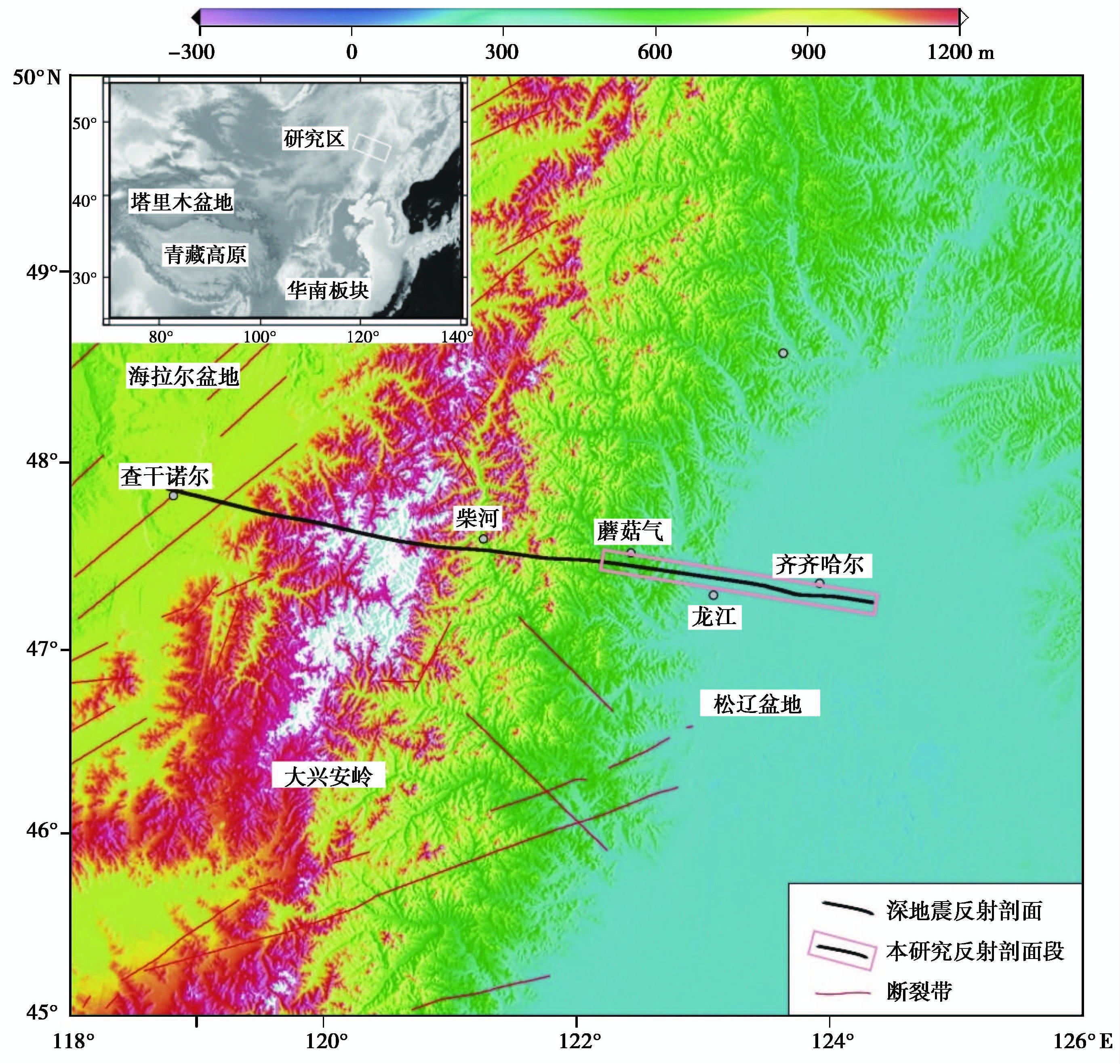
2011年,中国地质科学院岩石圈研究中心完成了跨越大兴安岭中部地区400km长的高精度深地震反射剖面。该剖面东起松辽盆地西缘,向西穿过大兴安岭主峰,止于海拉尔盆地(图 1)。本文利用跨越嫩江断裂带的150km的地震剖面资料,对该段地震剖面进行了较为详细的构造解释,揭示了嫩江断裂带的深部形态结构,以及两侧盆山的精细地壳结构。这将为探讨松辽盆地的沉积演化及与大兴安岭的盆山耦合关系、兴安地块与松嫩地块的性质,以及大兴安岭重力梯度带的成因等问题提供地震学依据。
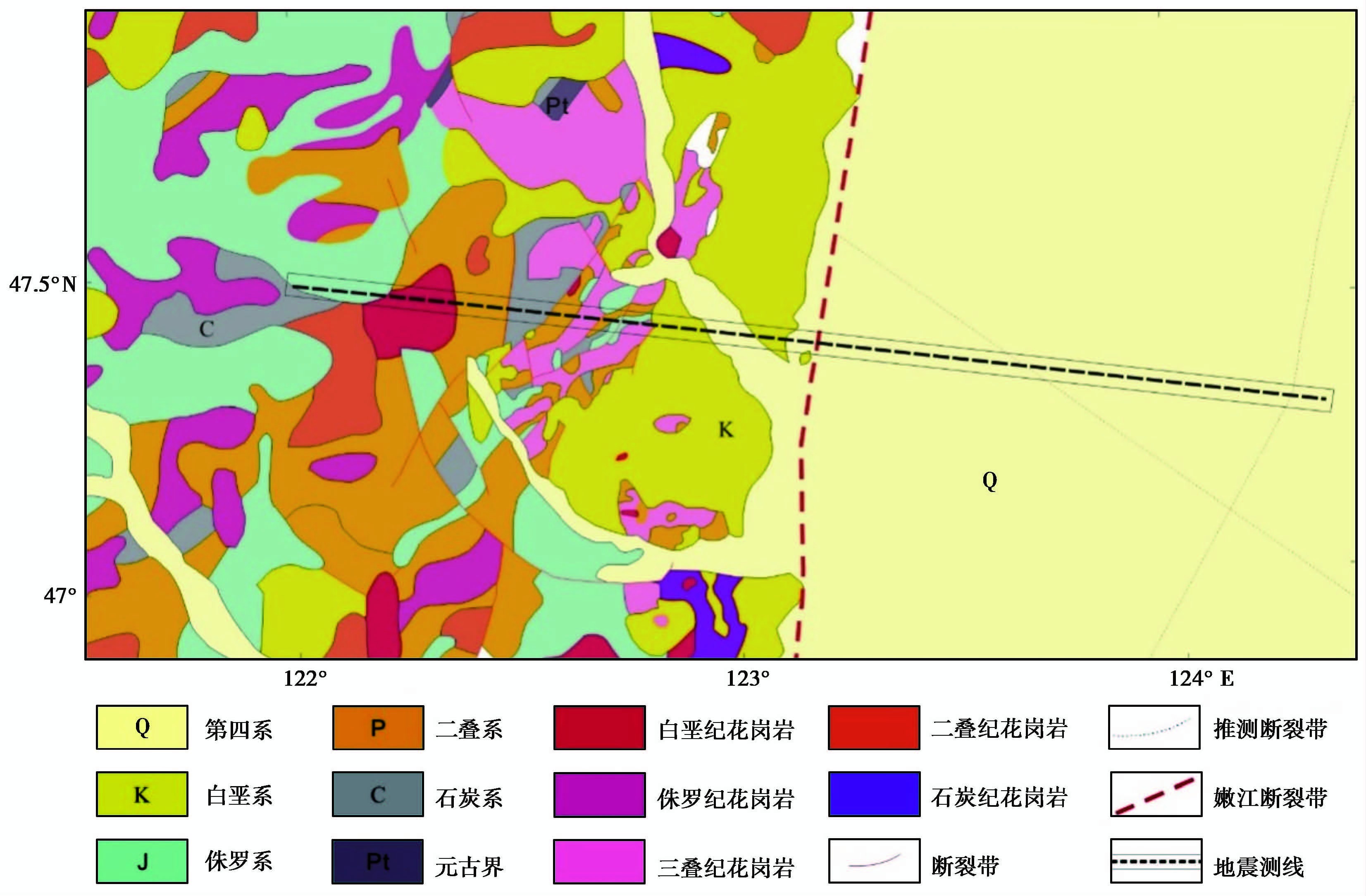
1 地质背景嫩江断裂带,是松辽盆地西缘与大兴安岭东缘的边界断裂带,位于东北地区中部,中亚造山带东段,其对东部的松辽中、新生代断拗盆地以及西部的大兴安岭早白垩世早期断陷盆地的形成和演化具有明显的控制作用(图 2;Su et al., 2013;Li et al., 2014b)。嫩江断裂带呈北北东走向,其命名始自于内蒙古自治区地质矿产局(1991)的《内蒙古自治区区域地质志》。其展布北自黑龙江省呼玛一带,然后向南沿嫩江流域经莫力达瓦旗,经黑龙江省齐齐哈尔以西和泰来镇,进入吉林省白城市,再延入内蒙古自治区境内扎鲁特旗以东,最后向南进入河北省境内,全长1200km(Nozaka and Liu, 2002;韩国卿,2008;Chen et al., 2013;Villaseca et al., 2014)。其北段一般被称为嫩江断裂带,南段则被称为红山—八里罕断裂,但大多数学者还是以嫩江断裂带代之(韩国卿,2008;韩国卿等,2009)。对于嫩江—八里罕断裂带的研究,尤其是北段,目前集中在区域地球物理方面,主要通过航磁异常、布格重力异常等确定断裂带的大致展布位置(Goleby,2000;Seltmann et al., 2011;Zhao et al., 2014);南段红山—八里罕断裂带则主要通过对喀喇沁隆起的研究,来探讨其形成时间、性质与演化阶段等(韩国卿等,2009)。

|
图1 大兴安岭地形及深地震反射剖面位置图 Fig.1 Topographic map of the Great Xing'an Range with the location of the deep seismic reflection profile |

|
图2 嫩江断裂带及周缘地质图 Fig.2 Geological map of Nenjiang fault zone and adjacent regions |
该断裂带传统上被认为是一条倾向向东的大型正断层或拆离断层(张贻侠等,1998;Hu et al., 2013;Peng et al., 2015),其具有韧性走滑性质的特征已经被越来越多的学者所发现(Jian et al., 2008;韩国卿等,2009;Chen et al., 2011;Xie et al., 2012),并且自早白垩世至新生代一直处于活动状态(Chen et al., 2000)。嫩江断裂带两侧的地球物理场、地貌、地层发育等特征具有明显差异,表明这是一条深大断裂(杨宝俊等,2005;刘财等,2011a;Zhang et al., 2013;Zhao et al., 2014)。由于中、新生代的嫩江断裂带左旋走滑断裂叠加在晚古生代黑河—贺根山板块拼接断裂带上,使得龙江—嫩江一代产生了复杂的构造叠加效应。沿断裂带两侧分布有古生代和中生代的中酸性侵入岩以及新生代的玄武岩(黑龙江省地质矿产局,1993;林存东等,2005)。
近年来,许多学者利用地球物理方法等多种技术手段对嫩江断裂带的形态结构和属性进行了深入的研究。其在卫星图片上显示为多条断续、平行分布的线性影像带。断裂带东西两侧的重力异常特征显示断裂西侧基底向上抬升。区域磁场显示在断裂带西侧为一系列强烈变化的南北向线性磁异常,而在断裂带以东以平缓的负场为主。据重磁场确定的断裂带倾向向东,属断阶式断裂,断裂东侧下降,西侧向上抬升(黑龙江省区域地质志,1993)。根据满洲里—绥芬河地学断面综合地球物理剖面的解释结果,嫩江断裂表现为向东的低角度正断层,该断层从大兴安岭构造带的东缘向东一直延伸到松辽盆地的西缘(张贻侠等,1998)。在松辽盆地的基底表现为基底拆离断层,而且其北界控制了基性火山活动的分布(王瑜等,1999)。从力学性质看,该断裂带具有张扭性质(万波等,1997)。断裂两侧的北西向断裂发育,它们切割了白垩纪之前的地质体,并沿断裂带两侧地震活动较强,是现代构造相当活跃的区域(陈洪洲等,2004)。
2 数据采集与处理地震测线采用直线施工,全长为400km。东起黑龙江齐齐哈尔市东,向西经龙江县、碾子山区、内蒙古扎兰屯市蘑菇气镇、柴河镇,止于新巴尔虎右旗查干诺尔镇。测线穿越了松辽盆地西缘、大兴安岭和海拉尔盆地东缘(图 1)。本文研究区范围为剖面东段,自嫩江东侧到蘑菇气镇,长约150km(图 1)。野外数据采集中,采用多种震源相结合的办法,兼顾地壳的上、中、下层。3种药量(500kg、100kg和24kg,分别称为大炮、中炮和小炮)的炸药震源激发并同时接收,以获得高分辨率的地震数据。野外采用法国Sercel 428XL数字地震仪进行数据采集。小炮炮间距为250m,井深为25m,720道接收;中炮炮间距为2000m,井深为35m,双井组合激发,720道接收。最小偏移距为25m,最大偏移距为17 975m。采样间隔为 2ms,具体的采集参数见 表 1。
| 表1 采集参数 Table 1 Acquisition parameter |
本次精细处理采用ProMAX、Tomodel、CGG和OMEGA等多个分析和处理软件相结合的方法,在详细分析原始资料的基础上,针对影响资料成像效果的主要问题,通过大量的对比和测试工作,确定最终的处理流程和关键处理技术。采用层析静校正方法以解决盆山结合带近地表静校正问题,采用叠前多域组合去噪技术进行去噪,采用地表一致性振幅补偿和振幅一致性反褶积解决了振幅、频率一致性的问题。在此基础上,通过高精度速度分析和剩余静校正的多次迭代解决了剩余静校正的问题,对数据进行了倾角校正(dmo)处理,以消除倾角对数据的影响,通过叠前时间偏移技术、聚焦同相轴和突出断点,提高了资料信噪比和剖面的成像质量。
3 深地震反射剖面解释深地震反射数据精细处理后的结果剖面显示了嫩江断裂带及两侧盆山的反射结构特征。在此基础上,我们对深地震反射剖面进行了较为详细的构造解释,揭示了嫩江断裂带的深部形态特征及其两侧盆山的精细地壳结构。
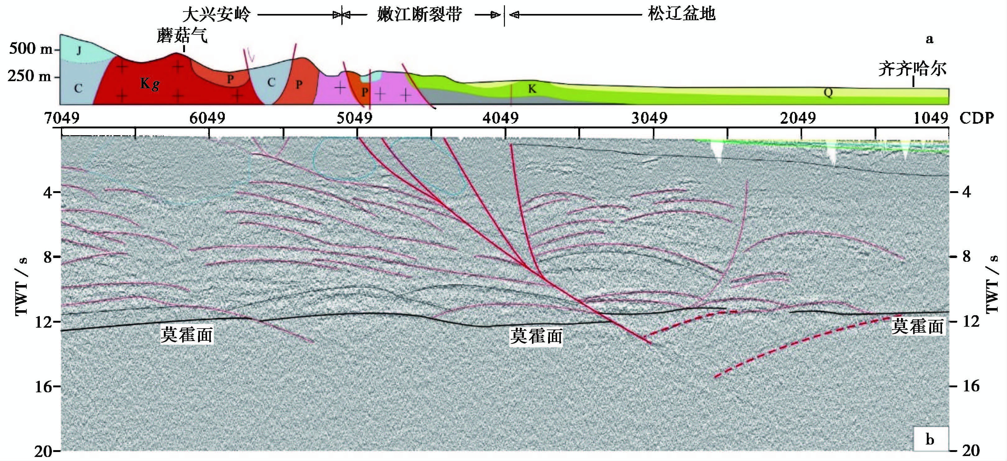
3.1 断裂带的位置、深部形态特征从深地震反射剖面上,可以清楚地看到嫩江断裂带是一条超壳断裂带,垂向东倾,延伸并切穿莫霍面。表现为花状构造样式,在中、上地壳有多条断裂带自地表向下延伸到9~10 s(双程走时TWT)并汇到一条断裂带上。多条断裂带均表现为倾向南东的特征,并且从地表到深部倾角逐渐变缓,同地表地质的断裂带位置一致。而在断裂带两侧,地壳结构存在明显差异。
断裂带上部,呈现近乎透明的反射特征或弱反射特征。一般认为透明地震反射区为岩浆侵入区(Mair and Green, 1981)。在断裂带以西的大兴安岭地区,介于CDP 5049~5549之间,0~3 s(TWT)之下,和介于CDP 5849~6649之间地壳上部的0~4 s(TWT)之下,可见透明反射区,结合地表地质,前者应代表三叠纪花岗岩侵入区,后者为白垩纪花岗岩侵入区。在断裂带以东的松辽盆地内,在地壳上部,可以看到在1 . 5 s以上有连续的沉积反射,结合区域地质,认为其代表了上白垩世的坳陷沉积(图 3中绿色部分),并向西尖灭于嫩江断裂带。其下可见断陷沉积区,深度约为3s左右,应代表下白垩世断陷沉积区(图 3 松辽盆地内黑细线)。

|
图3
跨越嫩江断裂带深地震反射剖面解释图 ;a. 沿线地质剖面;b. 深地震反射剖面解释图 Fig.3 Interpretation of the deep seismic reflection profile across Nenjiang fault zone |
断裂带两侧的中、下地壳内也存在差异。断裂带在 5 s(TWT)往下,可以看到一些弧形反射特征出现,下部东倾的反射组被断裂带的分支错断。断裂带切穿莫霍面后,接着往下延伸到近乎16 s(TWT)左右。断裂带以西的大兴安岭地壳内主要呈现出向东的反射组,而松辽盆地中下地壳内则呈现出明显的弧状反射组,在CDP 2349之下,以东的弧形反射和以西的弧形反射出现汇交和断点,推测其应该是松辽盆地西缘的中、下地壳深部断裂。同时,在松辽盆地之下存在两条地幔反射体,从地壳底部延伸到13 s和16 s,而后被嫩江断裂带截断,按照其切割关系来讲,嫩江断裂带应该在其之后发育。
3.2 莫霍面的综合形态和埋深深地震反射剖面显示,嫩江断裂带两侧的莫霍面存在差异。断裂带以东的松辽盆地的莫霍面近乎平行,在靠近断裂带附近呈现束状反射特征,在松辽盆地内部呈现线状特征,深度约为11s(TWT),按照地壳平均速度6.0km/s计算,换算成深度大概为33km;在断裂带以西的大兴安岭地壳底部,莫霍面呈现束状反射特征,在11.5~13 s(TWT)之间,换算成深度约为34.5~39km。宽度约为1~1.5 s(3~4.5km)。在CDP 5549~6049之间,莫霍面被错断。整体上,该区域莫霍面深度在11~13 s,东浅西深,同该区域宽角反射与折射剖面揭示的结果一致(李英康等,2014)。
4 讨 论前人的地球物理资料业已证实了嫩江断裂带是东西两侧地壳以及岩石圈的突变带,同时也是松辽盆地和大兴安岭之间重要的盆岭分界线(张兴洲等, 2006,2011b,2012,2015;刘财等,2011b;Liang et al., 2015)。
相比较其他地球物理资料,深地震反射剖面蕴含着丰富的地壳结构和构造信息。剖面上反射波能量及其波组特征的变化与地下结构和构造的赋存形态密切相关(Clowes et al., 1992;Cook,2002;Hammer et al., 2010)。由深地震反射剖面的揭示结果可以看到,嫩江断裂带是一个切割整个地壳的深大断裂带。前人曾根据沿嫩江断裂带分布的岩石年龄和地球化学特征,推测其生成时代为古生代末。沿大兴安岭北东向呈带状展布的活动陆缘钙碱性岩浆弧和高钾钙碱性二长花岗岩—钾长花岗岩(陈洪洲等,2004;周长勇等,2005;张彦龙等,2010;赵芝等, 2010a,2010b),其空间上依次叠置并具有从俯冲到碰撞后的连续演化特征,说明沿着大兴安岭东缘存在一条重要的碰撞拼合带(张兴洲等,2011a)。深地震反射剖面揭示在齐齐哈尔以西到龙江县之下存在西倾的地幔反射体,而与现今的嫩江断裂带之间不存在继承性。前人的大地电磁测深结果同样显示,在齐齐哈尔以西从地壳8~20km深,有一条低阻异常体向西倾斜(张兴洲等,2011a)。近期完成的大地电磁剖面揭示的大兴安岭和松辽盆地的电性岩石圈结构也显示,在龙江县之下存在一个西倾的低阻体(Liang et al., 2015;Xiong et al., 2015),都在现今的嫩江断裂带以西。结合北东向串珠状强磁异常带经过黑河—嫩江—白城一带(大庆油田石油地质编写组,1993),也是东北地区东西部岩石圈和莫霍面厚度突变带的区域(张贻侠等,1998),无根的超基性岩和大理岩岩块等强烈变形的岩石在白城附近洮5井约500m深处被钻到。张兴洲等(2011a)根据这些证据提出黑河—嫩江—白城一线的隐伏俯冲杂岩带向西倾斜。同时,西侧的晚古生代花岗岩平行俯冲带展布,该花岗岩带南端到伊尔施附近,并没有向南延伸到内蒙古中部(张兴洲等,2011a)。我们推测在石炭纪末期,松嫩地块与兴安地块之间的拼合在地幔岩石圈主要以向西俯冲为主,而兴安地块的地壳则向松嫩地块挤入,两者之间的拼合呈现鳄鱼嘴状关系,这种碰撞方式在欧洲华力西造山带和天山造山带曾被深地震反射剖面揭示(Meissner et al., 1990;Gao et al., 2013)。
深地震反射剖面揭示的嫩江断裂带的结构和几何形态与其动力学过程密切相关。满洲里—绥芬河地学断面解释结果认为,嫩江断裂带为一条向东倾斜的低角度正断层,并向下延达20余千米(陈洪洲等,2004;韩国卿,2008),断层的底部已近水平(金旭等,1994)。同时区域重力异常的形态及重磁场确定的断裂位置也支持该观点(陈洪洲等,2004)。新完成的大地电磁数据解释松嫩断裂带是一条东倾的断裂带,并不穿过莫霍面(刘财等,2011b)。但深地震反射剖面显示嫩江断裂带是一个以走滑为主的,并伴有逆冲和正断运动分量的复杂断裂构造带,该断裂带由浅到深依次切割了近地表沉积、壳内界面和莫霍面。其变形方式有规律地从脆性、脆韧性向韧性过渡。因此嫩江断裂带是一条深达莫霍面甚至切过莫霍面的深大断裂,而非如陈洪洲等(2004)所认为的是松辽盆地的拆离断层。控制着玄武质火山(如门鲁河火山、科洛火山、五大连池火山及二克山火山等)活动分布(王承祺等,1987;王瑜等,1999)的松辽盆地的基底拆离断层不属于嫩江断裂带。大地电磁资料认为在兴安地块和松嫩地块拼合空间存在岩石圈残片,并由于嫩江断裂带的左旋走滑作用,这些残片残留在大杨树盆地的上部基底空间(刘财等,2011b),在深地震反射剖面上并没有反映,但是在松辽盆地西缘地壳底部发现的西倾地幔反射体可能是莫霍面在后期构造过程中扮演了走滑断层的作用,致使现在的地幔反射体位置较晚古生代碰撞时期向东位移。这同前人(杨承先等,1984;张兴洲等,2012)根据区域重力异常梯度带并依据上延原理分析获得的嫩江断裂带向西倾伏的结果一致。
5 结 论(1) 嫩江断裂带目前呈现花状构造样式,同地表地质获得的左旋走滑结果一致。
(2) 嫩江断裂带并非松辽盆地内部的拆离断层,而是一条超壳断裂,控制了大兴安岭的物质东移和松辽盆地的中生代沉积。
(3) 现今的嫩江断裂带同晚古生代兴安地块与松嫩地块拼合的嫩江构造带并没有继承性关系;莫霍面可能在后期的演化过程中扮演了滑脱层的作用,致使向西俯冲的地幔体向东位移。
致谢 论文成稿过程中得到了张世红等学者的帮助,特致谢意。
| [1] | 陈洪洲, 余中元, 许晓艳等. 2004. 嫩江断裂构造及其与地震活动的关系. 防灾减灾学报,20 (4): 43-49. |
| [2] | Chen Hongzhou, Yu Zhongyuan, Xu Xiaoyan et al. 2004. Characteristics of Nenjiang fracture structure and the relation between this fracture and earthquake activity. Journal of Disaster Prevention and Reduction,20 (4): 43-49. |
| [3] | 大庆油田石油地质编写组. 1993. 中国石油地质志(卷二): 大庆、 吉林油田(上册). 北京: 石油工业出版社. 1-785. |
| [4] | Editorial Comittee of Daqing Oil field of “Petroleum Geology of China”. 1993. Petroleum Gelogoy of China (Vol. 2): Daqing, Jilin Oil Field. Beijing: Petruleum Industry Press. 1-785. |
| [5] | 葛文春, 吴福元, 周长勇等. 2005. 大兴安岭中部乌兰浩特地区中生代花岗岩的锆石U-Pb年龄及地质意义. 岩石学报,21 (3): 749-762. |
| [6] | Ge Wenchun, Wu Fuyuan, Zhou Changyong et al. 2005. Zircon U-Pb ages and its significance of the Mesozoic granites in the Wulanhaote region, central Da Hinggan Mountain. Acta Petrologica Sinica,21 (3): 749-762. |
| [7] | 韩国卿. 2008. 嫩江-八里罕断裂带构造变形特征研究(硕士学位论文), 长春: 吉林大学. 1-82. |
| [8] | Han Guoqing. 2008. The Study on Characteristics of Structural Deformation of the Nenjiang-Balihan fault belt in Northeastern China(Master's Thesis). Changchun: Jilin University. 1-82. |
| [9] | 韩国卿, 刘永江, 温泉波等. 2009. 嫩江-八里罕断裂带岭下韧性剪切带变形特征. 吉林大学学报(地球科学版),39 (3): 397-405. |
| [10] | Han Guoqing, Liu Yongjiang, Wen Quanbo et al. 2009. The characteristics of structural deformation for the Lingxia Ductile shear zone of Nenjing-Balihan fault belt in northeastern China. Journal of Jilin University(Earth Science Edition),39 (3): 397-405. |
| [11] | 韩国卿, 刘永江, Neubauer F等. 2012. 松辽盆地西缘边界断裂带中南段走滑性质、 时间及其位移量. 中国科学: 地球科学,42 (4): 471-482. |
| [12] | Han Guoqing, Liu Yongjiang, Neubauer F et al. 2012. Characteristics, timing, and offsets of the middle-southern segment of the western boundary strike-slip fault of the Songliao Basin in Northeast China. Science China Earth Science,55 (3): 464-475. |
| [13] | 黑龙江省地质矿产局. 1993. 黑龙江省区域地质志. 北京: 地质出版社. 1-734. |
| [14] | Heilongjiang Bureau of Geology and Mineral Resource. 1993. Regional Geology of Heilongjiang Province. Beijing: Geological Publishing House. 1-734. |
| [15] | 内蒙古自治区地质矿产局. 1991. 内蒙古自治区区域地质志. 北京: 地质出版社. 1-725. |
| [16] | Inner Mongolia Bureau of Geology and Mineral Resources. 1991. Regional Geology of Inner Mongolia. Beijing: Geological Publishing House. 1-725. |
| [17] | 金旭, 杨宝俊. 1994. 中国满洲里-绥芬河地学断面地球物理场及深部构造特征研究. 北京: 地震出版社. 30-50. |
| [18] | Jin Xu and Yang Baojun. 1994. Reaearch on Geophysical Fields and Deep Tectonics along Manzhouli-Suifenhe GGT in China. Beijing: Seismological Press. 30-50. |
| [19] | 李英康, 高锐, 姚聿涛等. 2014. 大兴安岭造山带及两侧盆地的地壳速度结构. 地球物理学进展,29 (1): 73-83. |
| [20] | Li Yingkang, Gao Rui, Yao Yutao et al. 2014. The crust velocity structure of Da Hinggan Ling orgenic belt and the basins on both side. Progress in Geophysics,29 (1): 73-83. |
| [21] | 林存东, 戴昕志, 李贵明等. 2005. 嫩江断裂带地震活动特征分析. 地震地磁观测与研究,26 (4): 18-21. |
| [22] | Lin Cundong, Dai Xinzhi, Li Guiming et al. 2005. Analysis of the earthquake activity characteristics around the Nenjiang fracture belt. Seismological and Geomagnetic Observation and Research,26 (4): 18-21. |
| [23] | 刘财, 杨宝俊, 王兆国等. 2011a. 大兴安岭西北部中新生代盆地群基底电性分带特征研究. 地球物理学报,54 (2): 415-421. |
| [24] | Liu Cai, Yang Baojun, Wang Zhaoguo et al. 2011a.A research on the geoelectrical banding characteristics of the bottom of the Mesozoic-Cenozoic Basin groups in the northwest of the Da Hinggan Ling fault.Chinese Journal of Geophysics,54 (2): 415-421. |
| [25] | 刘财, 杨宝俊, 王兆国等. 2011b. 松辽盆地西边界带深部构造: 地电学证据. 地球物理学报,54 (2): 401-406. |
| [26] | Liu Cai, Yang Baojun, Wang Zhaoguo et al. 2011b.The deep structure of the western boundary belt of the Songliao Basin: The geoelectric evidence. Chinese Journal of Geophysics,54 (2): 401-406. |
| [27] | 任纪舜. 1980. 中国大地构造及其演化. 北京: 科学出版社. 1-124. |
| [28] | Ren Jishun. 1980. Geotectonics of China and Its Evolution. Beijing: Science Press. 1-124. |
| [29] | 万波, 钟以章. 1997. 东北地区的新构造运动特征分析及新构造运动分区. 防灾减灾学报,13 (4): 64-75. |
| [30] | Wan Bo and Zhong Yizhang. 1997. Features analysis and divisions of new tectonic movement in Northeast China. Journal of Disaster Prevention and Reduction,13 (4): 64-75. |
| [31] | 王承祺, 杜向荣, 刘继贤. 1987. 科洛-五大连池-二克山火山群(第一章): 绪论. 东华理工大学学报(自然科学版),10 (2): 1-4. |
| [32] | Wang Chengqi, Du Xiangrong and Liu Jixian. 1987. Keluo-Wudalianchi-Erkeshan volcaonic groups(Chapter 1): Introduction. Journal of East China Institute of Technology(Natural Science Edition),10 (2): 1-4. |
| [33] | 王鸿祯. 1981. 从活动论观点论中国大地构造分区. 地球科学,14 (1): 42-66. |
| [34] | Wang Hongzhen. 1981. Geotectonic units of China from the view-point of mobilism. Earth Science,14 (1): 42-66. |
| [35] | 王瑜, 李春风, 陈洪洲. 1999. 中国东北地区新生代火山活动的构造背景. 地质论评,45 (增刊): 180-189. |
| [36] | Wang Yu, Li Chunfeng and Chen Hongzhou. 1999. Tectonic settings of Cenozoic volcanism in northeastern China. Geological Review,45 (suppl.): 180-189. |
| [37] | 徐备, 赵盼, 鲍庆中等. 2014. 兴蒙造山带前中生代构造单元划分初探. 岩石学报,30 (7): 1841-1857. |
| [38] | Xu Bei, Zhao Pan, Bao Qingzhong et al. 2014. Preliminary study on the pre-Mesozoic tectonic unit division of the Xing-Meng orogenic belt(XMOB). Acta Petrologica Sinica,30 (7): 1841-1857. |
| [39] | 杨宝俊, 刘万崧, 王喜臣等. 2005. 中国东部大兴安岭重力梯级带域地球物理场特征及其成因. 地球物理学报,48 (1): 86-97. |
| [40] | Yang Baojun, Liu Wansong, Wang Xicheng et al. 2005. Geophysical characteristics of Daxinganling gravitational gradient zone in the East China and its geodynamic mechanism. Chinese Journal of Geophysics,48 (1): 86-97. |
| [41] | 杨承先, 王贵华, 陈健. 1984. 内蒙红山-八里罕断裂带地质特征及其地震活动性. 地震研究,7 (4): 391-398. |
| [42] | Yang Chenxian, Wang Guihua and Chen Jian. 1984. The Hongshan-Balihan fault zone, Inner Mongolia: Its geologic features and seismicity. Journal of Seismilogical Research,7 (4): 391-398. |
| [43] | 张兴洲, 杨宝俊, 吴福元等. 2006. 中国兴蒙-吉黑地区岩石圈结构基本特征. 中国地质,33 (4): 816-823. |
| [44] | Zhang Xingzhou, Yang Baojun, Wu Fuyuan et al. 2006. The lithosphere structure in the Hingmong-Jihei(Hinggan-Mongolia-Jilin-Heilongjiang)region, northeastern China. Geology in China,33 (4): 816-823. |
| [45] | 张兴洲, 乔德武, 迟效国等. 2011a. 东北地区晚古生代构造演化及其石油地质意义. 地质通报,30 (2-3): 205-213. |
| [46] | Zhang Xingzhou, Qiao Dewu, Chi Xiaoguo et al. 2011a.Late-Paleozoic tectonic evolution and oil-gas potentiality in northeastern China. Geological Bulletin of China,30 (2-3): 205-213. |
| [47] | 张兴洲, 杨宝俊, 吴福元等. 2011b. 中国兴蒙-吉黑地区岩石圈三维结构及演化. 北京: 地质出版社. 1-254. |
| [48] | Zhang Xingzhou, Yang Baojun, Wu Fuyuan et al. 2011b.Three-Dimensional Structures and Evolution of Lithosphere in Northeast China. Beijing: Geological Publishing House. 1-254. |
| [49] | 张兴洲, 马玉霞, 迟效国等. 2012. 东北及内蒙古东部地区显生宙构造演化的有关问题. 吉林大学学报(地球科学版),42 (5): 1269-1285. |
| [50] | Zhang Xingzhou, Ma Yuxia, Chi Xiaoguo et al. 2012. Discussion on Phanerozoic tectonic evolution in northeastern China. Journal of Jilin University(Earth Science Edition),42 (5): 1269-1285. |
| [51] | 张兴洲, 郭冶, 曾振等. 2015. 东北地区中-新生代盆地群形成演化的动力学背景. 地学前缘,22 (3): 88-98. |
| [52] | Zhang Xingzhou, Guo Ye, Zeng Zhen et al. 2015. Dynamic evolution of the Mesozoic-Cenozoic basins in the northeastern China. Earth Science Frontiers,22 (3): 88-98. |
| [53] | 张彦龙, 葛文春, 高妍等. 2010. 龙镇地区花岗岩锆石U-Pb年龄和Hf同位素及地质意义. 岩石学报,26 (4): 1059-1073. |
| [54] | Zhang Yanlong, Ge Wenchun, Gao Yan et al. 2010. Zircon U-Pb ages and Hf isotopes of granites in Longzhen area and their geological implications. Acta Petrologica Sinica,26 (4): 1059-1073. |
| [55] | 张贻侠, 孙运生, 张兴洲等. 1998. 中国满洲里-绥芬河地学断面. 北京: 地质出版社. 1-53. |
| [56] | Zhang Yixia, Sun Yunsheng, Zhang Xingzhou et al. 1998. Manzhouli-Suifenhe Geoscience Transects. Beijing: Geological Publishing House. 1-53. |
| [57] | 赵芝, 迟效国, 刘建峰等. 2010a. 内蒙古牙克石地区晚古生代弧岩浆岩: 年代学及地球化学证据. 岩石学报,26 (11): 3245-3258. |
| [58] | Zhao Zhi, Chi Xiaoguo, Liu Jianfeng et al. 2010a.Late Paleozoic arc-related magmatism in Yakeshi region, Inner Mongolia: Chronological and geochemical evidence. Acta Petrologica Sinica,26 (11): 3245-3258. |
| [59] | 赵芝, 迟效国, 潘世语等. 2010b. 小兴安岭西北部石炭纪地层火山岩的锆石LA-ICP-MS U-Pb年代学及其地质意义. 岩石学报,26 (8): 2452-2464. |
| [60] | Zhao Zhi, Chi Xiaoguo, Pan Shiyu et al. 2010b.Zircon U-Pb LA-ICP-MS dating of Carboniferous volcanics and its geological significance in the northwestern Lesser Xing'an Range. Acta Petrologica Sinica,26 (8): 2452-2464. |
| [61] | 周长勇, 吴福元, 葛文春等. 2005. 大兴安岭北部塔河堆晶辉长岩体的形成时代、 地球化学特征及其成因. 岩石学报,21 (3): 763-775. |
| [62] | Zhou Changyong, Wu Fuyuan, Ge Wenchun et al. 2005. Age, geochemistry and petrogenesis of the cumulate gabbro in Tahe, northern Da Hinggan Mountain. Acta Petrologica Sinica,21 (3): 763-775. |
| [63] | Chen X, Shu L and Santosh M. 2011. Late Paleozoic post-collisional magmatism in the eastern Tianshan belt, Northwest China: New insights from geochemistry, geochronology and petrology of bimodal volcanic rocks. Lithos,127 (3-4): 581-598. |
| [64] | Chen B, Jahn B M, Wilde S et al. 2000. Two contrasting paleozoic magmatic belts in northern Inner Mongolia, China: Petrogenesis and tectonic implications. Tectonophysics,328 (1-2): 157-182. |
| [65] | Chen X, Shu L and Santosh M. 2011. Late Paleozoic post-collisional magmatism in the eastern Tianshan belt, Northwest China: New insights from geochemistry, geochronology and petrology of bimodal volcanic rocks. Lithos,127 (3-4): 581-598. |
| [66] | Chen X, Shu L, Santosh M et al. 2013. Island arc-type bimodal magmatism in the eastern Tianshan belt, Northwest China: Geochemistry, zircon U-Pb geochronology and implications for the Paleozoic crustal evolution in central Asia. Lithos,168 - 169 : 48-66. |
| [67] | Clowes R M, Cook F A, Green A G et al. 1992. Lithoprobe: New perspectives on crustal evolution. Canadian Journal of Earth Sciences,29 (9): 1813-1864. |
| [68] | Cook F A. 2002. Fine structure of the continental reflection Moho. Geological Society of America Bulletin,114 (1): 64-79. |
| [69] | Gao R, Hou H, Cai X et al. 2013. Fine crustal structure beneath the junction of the Southwest Tian Shan and Tarim Basin, NW China. Lithosphere,5 (4): 382-392. |
| [70] | Goleby B R, Bell B, Korsch R J et al. 2000. Crustal Structure and Fluid Flow in the Eastern Goldfields, Western Australia: Results from the Australian Geodynamics Cooperative Research Centre's(AGCRC)Yilgarn Deep Seismic Reflection Survey and Fluid Flow Modelling Projects. Canberra: Australian Geological Survey Organisation.1-109. |
| [71] | Gregori D A, López V L and Grecco L E. 2005. A Late Proterozoic-Early Paleozoic magmatic cycle in Sierra de la Ventana, Argentina. Journal of South American Earth Sciences,19 (2): 155-171. |
| [72] | Hammer P T C, Clowes R M, Cook F A et al. 2010. The Lithoprobe trans-continental lithospheric cross sections: Imaging the internal structure of the North American continent. Canadian Journal of Earth Sciences,47 (5): 821-857. |
| [73] | Hu P, Li C, Wang M et al. 2013. Cambrian volcanism in the Lhasa terrane, southern Tibet: Record of an Early Paleozoic Andean-type magmatic arc along the Gondwana proto-Tethyan margin. Journal of Asian Earth Sciences,77 : 91-107. |
| [74] | Jian P, Liu D, Kröner A et al. 2008. Time scale of an Early to Mid-Paleozoic orogenic cycle of the long-lived central Asian orogenic belt, Inner Mongolia of China: Implications for continental growth. Lithos,101 (3-4): 233-259. |
| [75] | Li J Y. 2006. Permian geodynamic setting of Northeast China and adjacent regions: Closure of the Paleo-Asian ocean and subduction of the paleo-Pacific plate. Journal of Asian Earth Sciences,26 (3-4): 207-224. |
| [76] | Li Y, Xu W L, Wang F et al. 2014a.Geochronology and geochemistry of Late Paleozoic volcanic rocks on the western margin of the Songnen-Zhangguangcai Range massif, NE China: Implications for the amalgamation history of the Xing'an and Songnen-Zhangguangcai Range massifs. Lithos,205 : 394-410. |
| [77] | Li Y L, Zhou H W, Brouwer F M et al. 2014b.Early Paleozoic to Middle Triassic bivergent accretion in the central Asian orogenic belt: Insights from zircon U-Pb dating of ductile shear zones in central Inner Mongolia, China. Lithos,205 : 84-111. |
| [78] | Liang H D, Gao R, Hou H S et al. 2015. Lithospheric electrical structure of the Great Xing'an Range. Journal of Asian Earth Sciences,113 (1): 501-507. |
| [79] | Mair J A and Green A G. 1981. High-resolution seismic reflection profiles reveal fracture zones within a ′homogeneous' granite batholith. Nature,294 (5840): 439-442. |
| [80] | Meissner R, Wever T and Sadowiak P. 1990. Reflectivity patterns in the Variscan Mountain belts and adjacent areas: An attempt for a pattern recognition and correlation to tectonic units. Tectonophysics,173 (1-4): DOI∶10.1016/0040-1951(90)90230-6. |
| [81] | Meng E, Xu W L, Pei F P et al. 2010. Detrital-zircon geochronology of Late Paleozoic sedimentary rocks in eastern Heilongjiang Province, NE China: Implications for the tectonic evolution of the eastern segment of the central Asian orogenic belt. Tectonophysics,485 (1-4): 42-51. |
| [82] | Nozaka T and Liu Y. 2002. Petrology of the Hegenshan ophiolite and its implication for the tectonic evolution of northern China. Earth and Planetary Science Letters,202 (1): 89-104. |
| [83] | Peng T, Fan W, Zhao G et al. 2015. Petrogenesis of the Early Paleozoic strongly peraluminous granites in the western South China block and its tectonic implications. Journal of Asian Earth Sciences,98 : 399-420. |
| [84] | Seltmann R, Konopelko D, Biske G et al. 2011. Hercynian post-collisional magmatism in the context of Paleozoic magmatic evolution of the Tien Shan orogenic belt. Journal of Asian Earth Sciences,42 (5): 821-838. |
| [85] | Su B X, Qin K Z, Tang D M et al. 2013. Late Paleozoic mafic-ultramafic intrusions in southern central Asian orogenic belt(NW China): Insight into magmatic Ni-Cu sulfide mineralization in orogenic setting. Ore Geology Reviews,51 : 57-73. |
| [86] | Tang G J, Wang Q, Wyman D A et al. 2010. Geochronology and geochemistry of Late Paleozoic magmatic rocks in the Lamasu-Dabate area, northwestern Tianshan(West China): Evidence for a tectonic transition from arc to post-collisional setting. Lithos,119 (3-4): 393-411. |
| [87] | Villaseca C, Merino E, Oyarzun R et al. 2014. Contrasting chemical and isotopic signatures from Neoproterozoic metasedimentary rocks in the central Iberian zone(Spain)of pre-Variscan Europe: Implications for terrane analysis and Early Ordovician magmatic belts. Precambrian Research,245 : 131-145. |
| [88] | Wang Z Z, Han B F, Feng L X et al. 2015. Geochronology, geochemistry and origins of the Paleozoic-Triassic plutons in the Langshan area, western Inner Mongolia, China. Journal of Asian Earth Sciences,97 : 337-351. |
| [89] | Xie S W, Wu Y B, Gao S et al. 2012. Sr-Nd isotopic and geochemical constraints on provenance of Late Paleozoic to Early Cretaceous sedimentary rocks in the Western Hills of Beijing, North China: Implications for the uplift of the northern North China Craton. Sedimentary Geology,245 - 246 : 17-28. |
| [90] | Xiong X S, Gao R, Li Y K et al. 2015. The lithosphere structure of the Great Xing'an Range in the eastern central Asian orogenic belt: Constrains from the joint geophysical profiling. Journal of Asian Earth Sciences:113 (1): 481-490. |
| [91] | Xu B, Charvet J, Chen Y et al. 2013. Middle Paleozoic convergent orogenic belts in western Inner Mongolia(China): Framework, kinematics, geochronology and implications for tectonic evolution of the central Asian orogenic belt. Gondwana Research,23 (4): 1342-1364. |
| [92] | Yu Q, Ge W C, Yang H et al. 2014. Petrogenesis of Late Paleozoic volcanic rocks from the Daheshen Formation in central Jilin Province, NE China, and its tectonic implications: Constraints from geochronology, geochemistry and Sr-Nd-Hf isotopes. Lithos,192 - 195 : 116-131. |
| [93] | Zhang W, Jian P, Kröner A et al. 2013. Magmatic and metamorphic development of anEarly to Mid-Paleozoic continental margin arc in the southernmost central Asian orogenic belt, Inner Mongolia, China. Journal of Asian Earth Sciences,72 : 63-74. |
| [94] | Zhao P, Fang J, Xu B et al. 2014. Early Paleozoic tectonic evolution of the Xing-Meng orogenic belt: Constraints from detrital zircon geochronology of western Erguna-Xing'an block, North China. Journal of Asian Earth Sciences,95 : 136-146 . |
2. Key Laboratory of Earthprobe and Geodynamics, MLR, Beijing 100037;
3. Research Center on Deep Exploration & Deep Exploration Symposium, Chinese Academy of Geological Sciences, Beijing 100037;
4. School of Prospecting & Surveying Engineering, Changchun Institute of Technology, Changchun 130021
 2016, Vol. 51


