2. School of Geology and Geophysics, University of Oklahoma, Norman, OK 73019
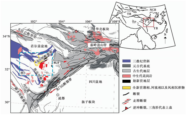
松潘—甘孜地块占据青藏高原东北缘,介于北侧的昆仑山断裂带和南侧的羌塘地块之间(图 1)。松潘—甘孜地块沉积了巨厚的三叠纪复理岩(Yin and Harrison,2000)。受印度—欧亚板块陆陆碰撞的影响,在青藏高原整体发生北东—东向物质逃逸。GPS测量结果显示,松潘—甘孜地块物质运移在接近四川盆地西缘的龙门山断裂带过程中,运移速率下降了10~15 mm/yr(Taylor and Yin,2009),并且在距离龙门山断裂带西侧约150 km处的龙日坝断裂带附近形成了一条速度梯度带(吕江宁等,2003;Shen et al.,2005)。沿龙日坝断裂带,在大约10 km的宽度内,运移速率从其西侧12 mm/yr的运移速率骤降到东侧的约3 mm/yr(King et al.,1997;Chen et al.,2000;吕江宁等,2003;Shen et al.,2005)。
|
图 1 青藏高原东缘地质图(基于 1︰250万中国地质图编制) 蓝色虚线框代表了文中所用的遥感卫星数据的获取范围。右上角图中的红色线框代表了研究区在中国大陆范围内的地理位置。NCB. 华北板块;YB. 扬子板块;TP. 青藏高原;TB. 塔里木盆地;SGT. 松潘—甘孜地块;MJF. 岷江断裂 Fig.1 Geological map of the eastern Tibetan Plateau(edited after the 1∶2.5 million geological map of China) |
龙日坝断裂带包括了西侧的右旋逆冲龙日曲断裂和东侧的纯右旋毛儿盖断裂(Xu et al. 2008;Ren et al.,2013a,2013b)。这两条平行的断裂间隔30 km宽,北东向大约延伸100 km。已有的研究表明,陆内大型走滑断裂带一般指示了此区域地壳物质分布存在线性差异(Molnar and Dayem,2010)。由此,龙日坝断裂带的存在已引起了广大地质学者的广泛兴趣(吕江宁等,2003;Shen et al.,2005;Xu et al.,2008;Ren et al.,2013a,2013b)。Xu et al.(2008)研究认为龙日坝断裂带的形成主要是受松潘—甘孜地块物质差异性运动造成的,但该研究并没有解释为什么会存在差异性。而这一问题反过来也是解决这一陆内走滑断裂带构造性质的关键。另外,抚边河左旋断裂带位于龙日坝断裂带东南侧,二者近乎垂直(图 1)。这一断裂带的存在也使龙日坝断裂带的成因变得扑朔迷离。除此之外,由于龙日坝断裂带西南侧的极端地形地质条件,没有办法开展区域地质调查,有关龙日坝断裂带的构造延伸也一直存在争议。有研究认为龙日坝断裂带已延伸至西侧的鲜水河断裂带附近(Xu et al.,2008),而也有研究认为龙日坝断裂带的延伸仅限于目前地表出露所指示的范围(郭晓玉等,2014)。
为了能够解决此争议,在本次研究中,我们将对研究区内现存的ALOS卫星PALSAR数据进行特殊处理,并由此来分析地表结构的活动分布特征,结果将用来厘定龙日坝断裂带的地表结构伸展。结合前人所做的研究区内地质地球物理研究,本次研究结果将有助于我们更深入了解龙日坝断裂带的构造属性,并由此了解青藏高原东缘相对于印度—欧亚板块碰撞的构造响应。
1 地质构造背景自从中生代以来,松潘—甘孜地块经历了复杂的多期次的构造事件,加上其位于青藏高原东北缘这一特殊的地理位置,松潘—甘孜地块已经吸引了国内外众多地质学者对其进行深入广泛的研究。然而,由于松潘—甘孜地块200 000 km2面积内沉积的巨厚复理石沉积物(Huang and Chen,1987;Nie et al.,1994;Zhou and Graham,1996;Chang,2000),松潘—甘孜地块的基底属性依旧是个谜。尽管对于松潘—甘孜地块内复理石的来源存在争议,大多数学者比较倾向的是这些复理石是直接沉积在一封闭古洋盆之上。这一古洋盆是在华南、 华北、 羌塘地块相互构造作用的基础上从古特提斯洋演化而来的(Yin and Nie,1993;Nie et al.,1994;Chang,2000;Pullen et al.,2008)。这一封闭古洋盆东侧连接的就是扬子板块,而南北两侧则同时分别被昆仑山俯冲带和甘孜—理塘俯冲带所包围(Roger et al.,2004;Harrowfield and Wilson,2005;Zhang et al.,2006)。双向挤压的结果造成了松潘—甘孜古洋盆内物质集体朝扬子板块的东向涌出(Roger et al.,2004,2010),从而形成了龙门山断裂带和目前松潘—甘孜地块内部广泛存在的三叠纪背斜(图 1)。
同时,由于松潘—甘孜古洋盆受到的强烈构造挤压,其内的沉积物也随之发生地壳缩短,地壳增厚。当地壳厚度达到50 km以上之后,松潘—甘孜古洋盆的洋壳被榴辉岩化,随之密度增大而发生洋壳的拆沉(Zhang et al.,2006,2007a,2007b)。洋壳拆沉造成地幔软流圈物质上涌,平铺在壳幔边界,从而使其上物质发生熔融。目前,松潘—甘孜地块东部广泛出露有花岗岩,主要为埃达克岩性质(袁海华等,1991,1994;Zhang et al.,2006,2007a;吕崧等,2010)。作为地球上最普遍分布的岩石之一,花岗岩本身所具有的一些指示信息是非常有意义的,例如:1)其同位素组构可以与具有某一特殊同位素地壳相吻合从而告诉我们这些花岗岩是从地球哪个部位形成的(Maniar and Piccoli,1989);2)花岗岩的年龄可以告诉我们岩浆的年龄,从而与某个构造活动联系起来,例如地壳构造拆沉(Sun et al.,2002);3)花岗岩的主要和微量元素组成(例如埃达克岩)可以用来指示地壳厚度以及源岩类型(榴辉岩和石榴角闪石)(Hacker,1996)。需要指出的是,埃达克岩质的花岗岩是由榴辉岩相或者石榴角闪岩相(也就是50 km深度范围内)的玄武岩质岩石熔融而形成的(Hacker,1996;Zhang et al.,2006)。由此,埃达克岩的存在和形成年龄可以告诉我们具有玄武岩性质基底的地壳增厚年龄。前人的地球化学研究结果表明,源于扬子板块下地壳熔融而形成的埃达克岩广泛分布在松潘—甘孜地块的东北部,而西南部并没有此类性质花岗岩的成规模的出露(图 1)。这一研究结果可以告诉我们松潘—甘孜地块最东缘巨厚沉积物下可能存在扬子板块性质的结晶基底(Zhang et al.,2006)。这一地球化学研究结果可与前人所做的地球物理学研究结果相对比(Guo et al.,2013,2014)。
晚中生代,松潘—甘孜地块处于相对的构造活动平静期(Burchfiel et al.,1995;Roger et al.,2011)。进入新生代,由于受印度—欧亚板块陆陆碰撞的影响,青藏高原物质发生侧向逃逸,而青藏高原东缘于晚中新世进入到快速隆升阶段(Clark et al.,2005)。青藏高原东缘、 东北缘断裂活动也逐步活跃起来。其中,沿龙门山断裂带监测到两期加速隆升期,分别在12~8 Ma和7~5 Ma(Arne et al.,1997;Kirby et al.,2002;Enkelmann et al.,2006;Kirby,2008;Ouimet et al.,2010;Wilson and Fowler,2011;Wang et al.,2012)。尽管如此,龙门山断裂带和四川盆地之间并没有观察到明显的构造挤压(挤压速率小于3 mm/yr)(Shen et al.,2005,2009;Gan et al.,2007)。沿松潘—甘孜地块北边界的昆仑山断裂带,左旋走滑起始时间被界定在大约15 Ma左右(Jolivet et al.,2003)。走滑运移速率朝昆仑山断裂带东缘呈逐级递减趋势:从若尔盖盆地西缘的12.5±2.5 mm/yr降到若尔盖盆地东缘塔藏断裂带的小于1 mm/yr(Kirby et al.,2007)。青藏高原东北缘,通过磷灰石裂变径迹方法监测到9~4 Ma的西秦岭快速冷却年龄(Enkelmann et al.,2006)。而位于松潘—甘孜地块内部的龙日坝断裂带,尽管目前并没有精确的测年来确定它的起始活动时间,但Xu et al.(2008)和Ren et al.(2013a)通过野外观测和14C和光释光测年方法认为龙日坝断裂带的构造活动始于晚第四纪,而且走滑速率从晚更新世的约7.5 mm/yr降到全新世时期的约2.1 mm/yr。另外,青藏高原东北缘地震活动频发,如:1933年叠溪7.5级大地震以及1976年松潘的7.2级、 6.7级和7.2级大地震(Chen et al.,1994)。然而,2008年之前的龙门山断裂带并没有大于7.0级以上的地震记录。同时,松潘—甘孜地块内部的龙日坝断裂带也并没有大地震发生过的记录,而古地震研究却显示龙日坝断裂带上曾经出现过7.0以上的地震活动(Ren et al.,2013b)。所以,这条活动的断裂带在将来也存在发生大地震的危险性。另外,Xu et al.(2008)研究表明,龙日坝断裂带构造活动始于晚第四纪,而且龙日坝断裂带所包含的龙日曲断裂和毛儿盖断裂具有不同的滑动速率。其中龙日曲断裂的右旋滑动速率为3.7±0.3 mm/yr,垂直运动速率为0.7 mm/yr。而毛儿盖断裂的右旋走滑速率为3.6±0.5 mm/yr。
2 卫星数据对地表结构延伸的控制 2.1 ALOS卫星PALSAR数据在本次研究中,我们采用日本先进陆地观测卫星(Advanced L and Observing Satellite,ALOS)的相控阵型L波段(波长为0.236 m)合成孔径雷达(Phased Array Type L-b and Synthetic Aperture Radar,PALSAR)数据来厘定研究区内地质结构的线性分布规律,以此来研究龙日坝断裂带的地表分布结构和构造延伸。PALSAR微波传感器可以获取单极化、 双极化和全极化的SAR数据。其工作的优势在于利用L长波段进行陆地观测时不受云的干扰并可以昼夜进行。另外,L波段由于其较长波长的特点,可以在相同时间间隔内,监测更广范围的细微地表形变,具有较高的相干性(吴宏安等,2011)。目前,PALSAR数据已被广泛应用在森林变化监测、 湿地洪水泛滥监测、 地下矿藏与地表形状的关联监测上,并可以用来分析地壳变动、 土地隆起、 土壤剥蚀等地形变化。
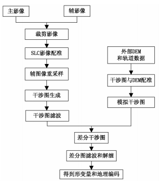
在此次研究中,我们共获得了12景上升轨道L波段数据,数据分布年限为2007~2011年。PALSAR影像参数如表 1所示。对PALSAR数据按照年份组成相应的干涉相对,其参数如表 2所示。我们利用GAMMA软件(Werner et al.,2001)对PALSAR数据进行合成孔径雷达干涉二轨法处理(处理流程如图 2所示),并利用SRTM DEM(90 m分辨率)去除地形相位,得到各时期差分干涉图。再对差分干涉图采用Delaunary方法进行解缠。该解缠方法将离散相干点若干没有重叠的三角形连接起来,并成对地用弧段将正负留数的节点连接起来。解缠时,避免积分路径穿过这些有正负留数的弧段,再利用最小费用流进行相位解缠。最终将解缠相位转换为雷达视向上的形变量,可得到2007~2008年,2008~2010年,2010~2011年时期雷达视向上的形变量。将各时期雷达视向形变结果叠加后除以时间,即可得到2007~2011年间平均形变速率(图 3)。
| 表 1 PALSAR影像参数 Table 1 PALSAR data parameters |
| 表 2 PALSAR干涉像对参数 Table 2 Main parameters used in InSAR processing |
|
图 2 二轨法数据处理流程 Fig.2 Procession flow of the ALOS-PALSAR data in “two-pass” method |
|
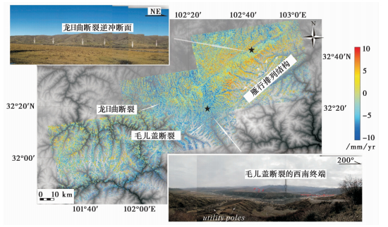
图 3 龙日坝断裂带及其附近区域地表形变平均视速度结果图 左上角和右下角照片分别代表了龙日曲断裂逆冲断面和毛儿盖断裂的西南端终结处,地理位置请参照图 1 Fig.3 Mean line of sight(LOS)velocities of the Longriba fault zone and adjacent areas |
如图 3所示,研究区内PALSAR数据处理所形成的平均形变速率(LOS)图可以大体上划为两个区域:龙日坝断裂带范围内的北东区域和南西区域。与龙日曲断裂和毛儿盖断裂相关的地表变形也清晰可见。龙日曲断裂两侧具有差异性活动特征。正的LOS值分布在龙日曲断裂的西北侧上盘,而东南侧的下盘则表现为负的LOS值。差异值大概与6~8 mm/yr的逆冲运移速率相吻合。野外地质也观测到了与龙日曲断裂逆冲相关的断裂面(如图 3左上角照片所示)。龙日曲断裂东侧的毛儿盖断裂两侧,平均形变速率图(图 3)中并没有观察到形变速率的差异性活动,这与前人研究得出的毛儿盖断裂为纯剪切断裂(Xu et al.,2008;Ren et al.,2013a)相一致。尽管如此,龙日曲断裂和毛儿盖断裂之间的雁行排列结构可以认为是伴随毛儿盖断裂右旋走滑所形成的(图 3)。另外,在抚边河断裂北西端附近,龙日曲断裂和毛儿盖断裂西南端点附近小规模北东—南西向LOS平均速度梯度带(图 3 中白色箭头所示)可以指示这两条断裂终止于此。以此往西南方向,我们并没有观测到明显的地表错断(图 3)。
因此,我们对平均形变速率结果的分析和解释表明龙日坝断裂带并没有继续延伸到鲜水河断裂带附近。相反,我们的研究认为,龙日坝断裂带终止在抚边河断裂带西北端附近,并与北西向延伸的抚边河断裂带近乎垂直。另外,地表地质也显示龙日坝断裂带与松潘—甘孜地块西南侧的三叠纪复理石背斜垂直,并在东侧切穿部分背斜结构(图 1)。毛儿盖断裂西南端点附近所拍摄的野外照片也可证实此现象(如图 3右下角照片所示)。再往西南,三叠纪复理石背斜可连续追踪,并没有出现被断裂切穿现象。
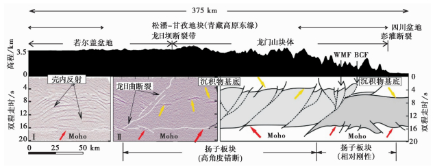
2.2 深部延伸的控制将北西—南东向展布的若尔盖深反射地震剖面(Wang et al.,2011)的南东段(图 4中Ⅰ)与国家专项“深部探测技术实验与集成”(SinoProbe-02)得到的龙门山断裂带深反射地震剖面(Guo et al.,2013)的北西段(图 4 中Ⅱ)重叠,通过这两部分已经发表的总共375 km的数据来探讨龙日坝断裂带在地表以下的构造变化情况。首先如图 4中高程变化所示,龙日坝断裂带两侧的高程变化出现差异。其北西侧高程变化相对于东南侧的高程变化较弱。其次,龙日坝断裂带北西侧壳内反射明显且复杂,且没有发现沉积物基底(图 4中Ⅰ)。龙日坝断裂带东南侧,壳内反射特征明显与北西侧的反射特征不同(图 4中Ⅱ)。 在这个区域内,沉积物基底明显可见。沉积物基底与莫霍面之间的壳内反射则相对平淡,不如其北西侧的反射特征强烈。由此可见,龙日坝断裂带可能为一构造边界,代表了两处不同物质属性的地块的拼合带。
|
图 4 研究区内龙日坝断裂带两侧现有的深反射地震剖面(Wang et al.,2011;Guo et al.,2014)以及青藏高原最东缘岩石圈结构部分解释结果 WMF. 汶川—茂文断裂;BCF. 北川断裂 Fig.4 Available long deep seismic reflection profiles on both sides of the Longriba fault and interpreted results regarding the crustal structure beneath easternmost Tibet |
Guo et al.(2013,2014)的研究表明扬子板块结晶基底可能存在于青藏高原的最东缘,受松潘—甘孜地块地壳缩短的影响已经被高度错断。这一现象可以与龙日坝断裂带以东的高程变化大相对应。此外,重磁数据研究也表明扬子板块北西侧已延伸越过龙门山断裂带进入松潘—甘孜地块内部,板块南西侧边界则逐渐向东归到龙门山断裂带(Guo et al.,2014),说明扬子板块西缘具有不规则板块边界,本文对龙日坝断裂带地表构造延伸和深部延伸构造特征的研究结果将有助于我们很好地了解龙日坝断裂带的构造属性。
综合以下研究区内的构造地质现象:1)龙日坝断裂带表现为一明显的速度梯度带;2)具有扬子板块基底属性的埃达克质花岗岩主要在松潘—甘孜地块东北部分布;3)深反射地震剖面中所显示的龙日坝断裂带两侧壳内反射特征明显不同;4)龙日坝断裂带在地表的构造延伸特征;5)松潘—甘孜地块地表三叠纪复理石背斜伸展特征:西南侧垂直于龙日坝和龙门山断裂带,北东侧则转为平行于龙日坝断裂带。 我们可以推测龙日坝断裂带具有很重要的大地构造属性,它可能代表了扬子板块的最西缘边界,从而支持了扬子板块西缘具有不规则板块边界的研究结论。龙日坝断裂带的前身可能为松潘—甘孜古洋盆与扬子板块的接触边界。随着三叠纪时期的挤压构造事件的发展,这一构造接触边界转变为古洋盆内部沉积物与扬子结晶基底西缘的接触边界。第四纪晚期,由于受印度—欧亚板块陆陆碰撞的影响,这一构造薄弱带被激活从而最终形成目前出露于地表的逆冲走滑断裂带。
| [1] | 郭晓玉,高锐, Keller G R等. 2014. 综合地球物理资料揭示青藏高原东缘龙日坝断裂带构造属性和大地构造意义.地球物理学进展, 29(5):2004-2012. |
| [2] | Guo Xiaoyu, Gao Rui, Keller G R et al. 2014. Integrated geophysical study on the tectonic feature of the Longriba fault zone in the eastern Tibetan Plateau, and the tectonic implications. Progress in Geophysics, 29(5):2004-2012. |
| [3] | 吕江宁,沈正康,王敏. 2003. 川滇地区现代地壳运动速度场和活动块体模型研究.地震地质, 25(4):544-554. |
| [4] | Lü Jiangning, Shen Zhengkang, Wang Min. 2003. Contemporary crustal deformation and active tectonic block model of the Sichuan-Yunnan region, China. Seismology and Geology, 25(4):544-554. |
| [5] | 吕崧,颜丹平,王焰等. 2010. 碧口地块麻山、木皮岩体岩石地球化学与地质年代学:对构造属性的指示意义.岩石学报, 26(6):1889-1901. |
| [6] | Lü Song, Yan Danping, Wang Yan et al. 2010. Geochemical and geochronological constraints on the Mashan and Mupi plutons in the South Qinling orogenic belt:Implications for tectonic nature of the Bikou terrane. Acta Petrologica Sinica, 26(6):1889-1901. |
| [7] | 吴宏安,张永红. 2011. ALOS/PALSAR InSAR数学模型研究.遥感信息,(2):106-110. |
| [8] | Wu Hong'an and Zhang Yonghong. 2011. Study on InSAR model of ALOS/PALSAR data. Remote Sensing Information,(2):106-110 |
| [9] | 袁海华,张志兰,张平. 1991. 龙门山老君沟花岗岩体的隆升及冷却史.成都地质学院学报, 18(1):17-22. |
| [10] | Yuan Haihua, Zhang Zhilan and Zhang Ping. 1991. The uplifting and cooling histories of the Laojungou granite in the western margin of the central section of the Longmen Mountains. Journal of Chengdu College of Geology, 18(1):17-22. |
| [11] | 袁海华,张志兰. 1994. 龙门山冲断带西侧印支-燕山期花岗岩类岩石年代学研究.见:罗志立主编,龙门山造山带的崛起和四川盆地的行程演化.成都:成都科技大学出版社. 330-336. |
| [12] | Yuan Haihua and Zhang Zhilan. 1994. A study of the chronology of granitoid rocks in Indosinian-Yanshan period at the West Longmen Mountains. In:Luo Zhili(Ed.). Uplifting of Lonmen Mountains and Formation and Evolution of Sichuan Basin. Chengdu:Chengdu University of Science and Technology Press. 330-337. |
| [13] | Arne D, Worley B, Wilson C et al. 1997. Differential exhumation in response to episodic thrusting along the eastern margin of the Tibetan Plateau. Tectonophysics, 280(3-4):239-256. |
| [14] | Burchfiel B C, Chen Z L, Liu Y P et al. 1995. Tectonics of the Longmenshan and adjacent regions, central China. International Geology Review, 37(8):661-735. |
| [15] | Chang E Z. 2000. Geology and tectonics of the Songpan-Ganzi fold belt, southwestern China. International Geology Review, 42(9):813-831. |
| [16] | Chen S F, Wilson C J L, Deng Q D et al. 1994. Active faulting and block movement associated with large earthquakes in the Min Shan and Longmen Mountains, northeastern Tibetan Plateau. Journal of Geophysical Research, 99(B12):24025-24038. |
| [17] | Chen Z, Burchfiel B C, Liu Y et al. 2000. Global Positioning System measurements from eastern Tibet and their implications for India/Eurasia intercontinental deformation. Journal of Geophysical Research, 105(B7):16215-16227. |
| [18] | Clark M K, House M A, Royden L H et al. 2005. Late Cenozoic uplift of southeastern Tibet. Geology, 33(6):525-528. |
| [19] | Enkelmann E, Ratschhacher R and Jonckheere R. 2006. Cenozoic exhumation and deformation of northeastern Tibet and the Qinling:Is Tibetan lower crustal flow diverging around the Sichuan Basin?GSA Bulletin, 118(5-18):651-671. |
| [20] | Gan W J, Zhang P Z, Shen Z K et al. 2007. Present-day crustal motion within the Tibetan Plateau inferred from GPS measurements. Journal of Geophysical Research, 112(B8):doi:10.1029/2005JB004120. |
| [21] | Guo X Y, Gao R, Keller G R et al. 2013. Imaging the crustal structure beneath eastern Tibet and implications for the uplift of Longmen Shan range. Earth and Planetary Science Letters, 379:72-80. |
| [22] | Guo X Y, Keller G R, Gao R et al. 2014. Irregular western margin of the Yangtze block as a cause of variation in tectonic activity along the Longmen Shan fault zone, eastern Tibet. International Geology Review, 56(4):473-480. |
| [23] | Hacker B R. 1996. Eclogite formation and the rheology, buoyancy, seismicity, and H2O content of oceanic crust. In:AGU Monograph. 337-346. |
| [24] | Harrowfield M J and Wilson C J L. 2005. Indosinian deformation of the Songpan Garzê fold belt, northeast Tibetan Plateau. Journal of Structural Geology, 27(1):101-117. |
| [25] | Huang J Q and Chen B W. 1987. The Evolution of the Tethys in China and Adjacent Regions. Beijing:Geological Publishing House. 1-251. |
| [26] | Jolivet M, Brunel M, Seward D et al. 2003. Neogene extension and volcanism in the Kunlun fault zone, northern Tibet:New constraints on the age of the Kunlun fault. Tectonics, 22(5):doi:10.1029/2002TC001428. |
| [27] | King R W, Shen F, Burchfiel B C et al. 1997. Geodetic measurements of crustal motion in Southwest China. Geology, 25(2):179-182. |
| [28] | Kirby E, Reiners P W, Krol M A et al. 2002. Late Cenozoic evolution of the eastern margin of the Tibetan Plateau:Inferences from 40Ar/39Ar and(U-Th)/He thermochronology. Tectonics, 21(1):doi:10.1029/2000TC001246. |
| [29] | Kirby E, Harkins N, Wang E et al. 2007. Slip rate gradients along the eastern Kunlun fault. Tectonics, 26(2):doi:10.1029/2006TC002033. |
| [30] | Kirby E. 2008. Geomorphic insights into the growth of eastern Tibet and implications for the recurrence of great earthquakes. In:AGU Fall Meeting Abstracts. T24B-03. |
| [31] | Maniar P D and Piccoli P M. 1989. Tectonic discrimination of granitoids. GSA Bulletin, 101(5):635-643. |
| [32] | Molnar P and Dayem K E. 2010. Major intracontinental strike-slip faults and contrasts in lithospheric strength. Geosphere, 6(4):444-467. |
| [33] | Nie S, Yin A, Rowley D B et al. 1994. Exhumation of the Dabie Shan ultra-high-pressure rocks and accumulation of the Songpan-Ganzi flysch sequence, central China. Geology, 22(11):999-1002. |
| [34] | Ouimet W, Whipple K, Royden L et al. 2010. Regional incision of the eastern margin of the Tibetan Plateau. Lithosphere, 2(1):50-63. |
| [35] | Pullen A, Kapp P, Gehrels G et al. 2008. Triassic continental subduction in central Tibet and Mediterranean-style closure of the Paleo-Tethys ocean. Geology, 36(5):351-354. |
| [36] | Ren J J, Xu X W, Yeats R S et al. 2013a. Latest Quaternary paleoseismology and slip rates of the Longriba fault zone, eastern Tibet:Implications for fault behavior and strain partitioning. Tectonics, 32(2):216-238. |
| [37] | Ren J J, Xu X W, Yeats R S et al. 2013b. Holocene paleoearthquakes of the Maoergai fault, eastern Tibet. Tectonophysics, 590:121-135. |
| [38] | Roger F, Malavieille J, Leloup P H et al. 2004. Timing of granite emplacement and cooling in the Songpan-Ganzi fold belt(eastern Tibetan Plateau)with tectonic implications. Journal of Asian Earth Science, 22(5):465-481. |
| [39] | Roger F, Jolivet M and Malavieille J. 2010. The tectonic evolution of the Songpan-Garzê(North Tibet)and adjacent areas from Proterozoic to Present:A synthesis. Journal of Asian Earth Sciences, 39(4):254-269. |
| [40] | Roger F, Jolivet M, Cattin R et al. 2011. Mesozoic-Cenozoic tectonothermal evolution of the eastern part of the Tibetan Plateau(Songpan-Garzê, Longmen Shan area):Insights from thermochronological data and simple thermal modelling. Geological Society, London, Special Publications, 353(1):9-25. |
| [41] | Shen Z K, Lü J N, Wang M et al. 2005. Contemporary crustal deformation around the southeast borderland of the Tibetan Plateau. Journal of Geophysical Research, 110(B11):doi:10.1029/2004JB003421. |
| [42] | Shen Z K, Sun J B, Zhang P Z et al. 2009. Slip maxima at fault junctions and rupturing of barriers during the 2008 Wenchuan earthquake. Nature Geoscience, 2:718-724. |
| [43] | Sun W D, Li S G, Chen Y D et al. 2002. Timing of synorogenic granitoids in the south Qinling, central China:Constraints on the evolution of the Qinling-Dabie Shan orogenic belt. Journal of Geology, 110(4):457-468. |
| [44] | Taylor M and Yin A. 2009. Active structures of the Himalayan-Tibetan orogeny and their relationships to earthquake distribution, contemporary strain field, and Cenozoic volcanism. Geosphere, 5(3):199-214. |
| [45] | Wang C S, Gao R, Yin A et al. 2011. A mid-crustal strain-transfer model for continental deformation:A new perspective from high-resolution deep seismic-reflection profiling across NE Tibet. Earth and Planetary Science Letters, 306(3-4):279-288. |
| [46] | Wang E, Kirby E, Furlong K P et al. 2012. Two-phase growth of high topography in eastern Tibet during the Cenozoic. Nature Geoscience, 5:640-645. |
| [47] | Werner C, Wegmüller U, Strozzi T et al. 2000. GAMMA SAR and interferometric processing software. In:ERS-ENVISAT Symposium, Gothenburg, Sweden. |
| [48] | Wilson C J L and Fowler A P. 2011. Denudational response to surface uplift in east Tibet:Evidence from apatite fission-track thermochronology. GSA Bulletin, 123(9-10):1966-1987. |
| [49] | Xu X W, Wen X Z, Chen G H et al. 2008. Discovery of the Longriba fault zone in eastern Bayan Har block, China and its tectonic implication. Science in China(Series D), 51(9):1209-1223. |
| [50] | Yin A and Nie S. 1993. An indentation model for the North and South China collision and the development of the Tan-Lu and Honam fault systems, eastern Asia. Tectonics, 12(4):801-813. |
| [51] | Yin A and Harrison T M. 2000. Geologic evolution of the Himalayan-Tibetan orogen. Annual Review of Earth and Planetary Sciences, 28(1):211-280. |
| [52] | Zhang H F, Zhang L, Harris N et al. 2006. U-Pb zircon ages, geochemical and isotopic compositions of granitoids in Songpan-Ganzi fold belt, eastern Tibetan Plateau:Constraints on petrogenesis and tectonic evolution of the basement. Contributions to Mineralogy and Petrology, 152(1):75-88. |
| [53] | Zhang H F, Xiao L, Zhang L et al. 2007a. Geochemical and Pb-Sr-Nd isotopic compositions of Indosinian granitoids from the Bikou block, northwest of the Yangtze plate:Constraints on petrogenesis, nature of deep crust and geodynamics. Science in China(Series D), 50(7):972-983. |
| [54] | Zhang H F, Parrish R, Zhang L et al. 2007b. A-type granite and adakitic magmatism association in Songpan-Garze fold belt, eastern Tibetan Plateau:Implication for lithospheric delamination. Lithos, 97(3-4):323-335. |
| [55] | Zhou D and Graham S A. 1996. Songpan-Ganzi Triassic flysch complex of the West Qinling Shan as a remnant ocean basin. In:Yin A and Harrison M(Eds.). The Tectonic Evolution of Asia. Cambridge:Cambridge University Press. 281-299. |
2. School of Geology and Geophysics, University of Oklahoma, Norman, OK 73019
 2016, Vol. 51


